Visual Materials
Chart and Plan of the Harbour of New York & the Couny. Adjacent, from Sandy Hook to Kingsbridge, Comprehending the Whole of New York and Staten Islands, and Part of Long Island & the Jersey Shore: And shewing the Defences of New York Both by Land and Sea

You might also be interested in
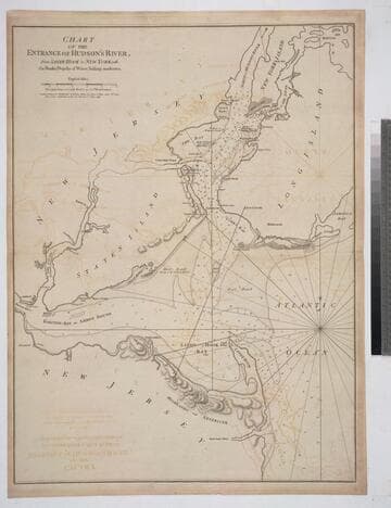
Chart of the Entrance of Hudson's River, from Sandy Hook to New York, with the Banks, Depths of Water, Sailing-marks &ca
Visual Materials
Kashnor notes, " The first issue of this chart. It was reissued in 1800 by Laurie & Whittle, but without date." Relief: hachures. Graphic Scale: Miles. Projection: Plane. Watermark: Crowned fleur-di-lis VI. Printing Process: Copper engraving. Verso Text: MS notes: 3 578.
105:578 M

Chart of the Entrance to Hudson's River, from Sandy Hook to New York, with the Banks, Depths of Water, Sailing-marks, &ca
Visual Materials
Kashnor notes, "A scarce chart, issued during the early period of the American Revolution." Found in North-American pilot for New England, New York, Pensilvania (sic), Maryland, and Virginia 1777, per RLIN record. Relief: hachures. Graphic Scale: Miles, English. Projection: Plane. Watermark: Crowned fleur-di-lis. Printing Process: Copper engraving. References: Phillips 1209. Verso Text: MS note: 105.
093:105 M

Map of the Country round Philadelphia including part of New Jersey New York Staten Island & Long Island
Visual Materials
Kashnor notes, "a scarce war map." MS note: 121 (on backing). Prime meridian: London. Relief: pictorial. Graphic Scale: Miles, British Statute. Projection: Cylindrical. Watermark: Crowned seal. Printing Process: Copper engraving. Verso Text: MS note: 121 (on backing).
093:121 S

New and Accurate Chart of the Harbour of Boston, in New England, in North America
Visual Materials
MS note: 110 (on backing). Relief: hachures. Graphic Scale: Miles. Projection: Plane. Printing Process: Copper engraving.
105:110 S

Plan of the City and Environs of New York in North America
Visual Materials
Kashnor dates as circa. 1776. Place and appeared in from RLIN record. Colorful map. MS note: 128 (on backing). Relief: hachures. Graphic Scale: Feet. Projection: Plane. Watermark: Seal Crowned CR lettering. Printing Process: Copper engraving. Other Features: Art Work.
105:128 S

Plan of the Attack on the Provincial Army on Long Island, August 27th 1776, With the Draughts of New York Island, Staten Island, And the Adjacent Part of the Continent By an Officer of the Army
Rare Books
MS note: 38. Prime meridian: GM. Relief: hachures. Projection: Plane. Watermark: Crowned LVC IV. Printing Process: Copper engraving.
295802