Visual Materials
Map of the Country round Philadelphia including part of New Jersey New York Staten Island & Long Island

You might also be interested in
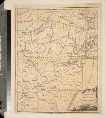
New and Accurate Map of the Present Seat of War in North America, Comprehending New Jersey, Philadelphia, Pensylvania (sic), New-York &c
Visual Materials
Kashnor dates as c.1770. Probably later because of reference to Revolutionary War. Some notes regarding boundary dispute between New York and New Jersey. Small vined cartouche with sailing ship. MS note: 101 (on backing). Prime meridian: London. Relief: pictorial. Graphic Scale: Miles, statute. Projection: Cylindrical. Watermark: Crowned seal. Printing Process: Copper engraving. Other Features: Cartouche. Verso Text: MS note: 410 (map) 101 (on backing).
093:101 S
Image not available
A map of the country round Philadelphia : including part of New Jersey New York Staten Island & Long Island
Visual Materials
Kashnor dates as ca. 1760. Jolly identifies as from Gentleman's Magazine, of Sept. 1776 [as does printing transfer on verso]. MS note: 729 (on backing). Prime meridian: London. Relief: pictorial. Graphic Scale: Miles. Projection: Cylindrical. Printing Process: Copper engraving. References: Jolly, Brit. Periodicals Gent-247. Verso Text: Text transfer.
105:729 S
Image not available
Map of New England and Nova Scotia; with part of New York, Canada, and New Britain & the adjacent Islands of New Found Land Cape Breton &c. by Tho. Kitchin Geogr
Visual Materials
Kashnor notes, "A scarce map issued at the time of the Old French War." RLIN record gives date and published in information. Cartouche: harbor/forest scene. MS note: 280 (on backing). Prime meridian: London. Relief: pictorial. Graphic Scale: Miles. Projection: Cylindrical. Watermark: Seal circular device. Printing Process: Copper engraving. Other Features: Cartouche. References: Kershaw 708; McCorkle 758.7. Verso Text: MS note: 280 (on backing).
093:280 S

A new and accurate map of the province of Georgia in North America
Visual Materials
Kashnor notes, "Shows the old trading paths and the Hunting Grounds of the Cherokees." Kashnor dates c.1776. RLIN record notes date as [1779?] and place of publication as [London?] and as appearing in The Universal Magazine of 1779. See 093:391 and 105:103 for additional copies. MS note: 94 (on backing). Prime meridian: [Ferro]. Relief: pictorial. Projection: Cylindrical. Watermark: Crowned circular seal. Printing Process: Copper engraving. Other Features: Cartouche. Verso Text: MS note: 32 94(on backing).
093:094 S

New and Accurate Map of the Chief Parts of South Carolina, and Georgia, From the Best Authorities
Visual Materials
Kashnor notes, "Published during the Revolution, this map shows the main roads in both provinces." See 093:076S for another copy. District and Township lines marked. MS note: 75 (on backing). Prime meridian: London. Relief: no. Graphic Scale: Miles. Projection: Cylindrical. Watermark: Crowned circle with lion clutching arrows. Printing Process: Copper engraving. Verso Text: MS note: 75 (on backing).
093:075 S
Image not available
A new and accurate map of the province of Georgia in North America
Visual Materials
Kashnor notes, "Shows the old trading paths and the Hunting Grounds of the Cherokees." Kashnor dates c.1776. RLIN record notes date as [1779?] and place of publication as [London?] and as appearing in The Universal Magazine of 1779. See 093:391 and 105:103 for additional copies. MS note: 391 (on backing). Prime meridian: [Ferro]. Relief: pictorial. Projection: Cylindrical. Watermark: Crowned circular seal. Printing Process: Copper engraving. Other Features: Cartouche. Verso Text: MS note: 391 (on backing).
093:391 M