Visual Materials
New and Accurate Map of Virginia & Maryland Laid Down from Surveys and Regulated by Astron'l Observat'ns. By Eman. Bowen
You might also be interested in
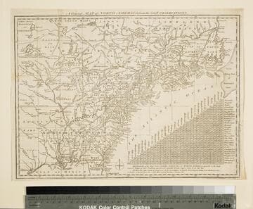
General Map of North America from the Latest Observations
Visual Materials
Kashnor gives date as [1776] RLIN record suggests 1778. Map includes distance chart between 29 American and Canadian cities. Bounds of Hudsons Bay [Co.] shown by Treaty of Utrecht. MS note: 102 (on backing). Prime meridian: London. Relief: pictorial. Projection: Mercator. Printing Process: Copper engraving. Verso Text: MS note: 1776.
105:102 S

An accurate map of New Hampshire in New England, from a late survey
Visual Materials
Kashnor dates as ca. 1776. Maine is shown as part of New Hampshire. RLIN record gives place of publication, date, and appeared in information as Universal magazine of knowledge and pleasure, March, 1781. MS note: 112 (on backing). Prime meridian: London. Relief: pictorial. Projection: Cylindrical. Watermark: Seal. Printing Process: Copper engraving. References: McCorkle N781.1.
105:112 S
Image not available
Accurate Map of Louisiana, and the Territory in Dispute between the English & French
Visual Materials
Kashnor notes, "Includes parts of Virginia, North and South Carolina, Georgia and Florida." Kashnor dates as ca. 1755. RLIN record suggests 1761. RLIN record covers a photocopy but is included to add data of appeared in information. MS note: 421 (on backing). Prime meridian: London. Relief: pictorial. Graphic Scale: Miles. Projection: Pseudocylindrical. Printing Process: Copper engraving. Verso Text: MS note: 421 (on backing).
093:421 S

A New and Accurate Map of Virginia, and Part of Maryland and Pennsylvania
Visual Materials
Kashnor notes, "This takes in also the Delaware Counties and part of New Jersey. A scarce map, issued during the Revolution." "Jno. Lodge Sculp." Appeared in information from RLIN record. MS note: 515 (on backing). Prime meridian: London. Relief: pictorial. Projection: Mercator. Printing Process: Copper engraving.
105:515 S
Image not available
Virginia, Maryland, Pennsilvania, East & West New Jarsey
Visual Materials
Kashnor notes, "a valuable and rare chart." Kashnor dates as ca. 1685. RLIN record suggests date of 1689, gives appeared in information. Relief: no. Graphic Scale: Leagues. Projection: Cylindrical. Printing Process: Copper engraving. Other Features: Cartouche. Verso Text: MS note: 825.
105:825 M

A new and accurate map of New Jersey, from the best authorities
Visual Materials
RLIN reference gives author, place of production, and notes this map is from Universal Magazine, v. 66, June 1780. Kashnor dates as circa 1780. MS note: 113 (on backing). Prime meridian: London. Relief: pictorial. Projection: Mercator. Watermark: Seal. Printing Process: Copper engraving.
105:113 S