Visual Materials
Virginia, Maryland, Pennsilvania, East & West New Jarsey
You might also be interested in
Image not available
A New Chart of the Sea Coast of Newfoundland, new Scotland, new England, Virginia, Maryland, Pennsilvania, and part of Carolina
Visual Materials
Kashnor notes, "a very fine old chart." Kashnor dates as [1685]. Royal coat of arms.. Relief: no. Graphic Scale: Leagues. Projection: Cylindrical. Printing Process: Copper engraving. Other Features: Cartouche. Verso Text: MS note: 335 (on backing).
105:335 M
Image not available
Carte Particuliere de Virginie, Maryland, Pennsilvanie, La Nouvelle Jarsey Orient et Occidentale
Visual Materials
Kashnor notes, "A good chart of the coast from Staten Island to Cape Henry." Kashnor dates as ca. 1700. RLIN record supplies appeared in information, dates 1693/1710. Relief: no. Graphic Scale: Leagues. Projection: Cylindrical. Watermark: P. Printing Process: Copper engraving. Verso Text: MS note: 514 17.
105:514 M
Image not available
New and Accurate Map of Virginia & Maryland Laid Down from Surveys and Regulated by Astron'l Observat'ns. By Eman. Bowen
Visual Materials
Kashnor dates as ca. 1750. RLIN record suggests 1792, gives appeared in information. Shadow of text transfer on map surface. MS note: 820 (on backing).. Prime meridian: London. Relief: no. Graphic Scale: Miles. Projection: Cylindrical. Printing Process: Copper engraving. Verso Text: Shadow of text transfer on verso..
105:820 S
Image not available
A New and accurate Map of the Province of Virginia, in North America
Visual Materials
Kashnor dates as ca. 1750. Shows London, Maryland. Jolly gives appeared in information and later dating. RLIN record supplies cartographer. MS note: 105/819 (on backing). Prime meridian: London. Relief: pictorial. Projection: Cylindrical. Watermark: Two seals. Printing Process: Copper engraving. Other Features: Cartouche. References: Jolly UNIV-183; Phillips Maps p.983..
105:819 M
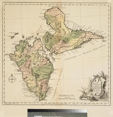
Guadaloupe one of the Caribbee Islands Subject to France in the West Indies, from the Best Authorities By T. Jefferys
Visual Materials
Kashnor dates as [1760]. RLIN record suggests 1768 and provides appeared in information. Cartouche: water falls & plants. Oversize binding spine still attached. Note: mile and league scales do not match.. Prime meridian: Ferro, London. Relief: pictorial & hachures. Graphic Scale: Miles, leagues. Projection: Cylindrical. Watermark: Crowned fleur-de-lis VI. Printing Process: Copper engraving. Other Features: Cartouche. Verso Text: MS notes: 93/775 148 La Guadaloupe La Guadalupe .
093:775 M
Image not available
A New and Accurate Map of Peru, and the country of the Amazones
Visual Materials
Kashnor notes, "Indicates Parima Lake and the famour city of El Dorado two degrees North of the Equator." Kashnor dates as ca. 1760. RLIN record suggests 1747 as publication data. Cartouche: Decorative shell.. "Drawn from the most authentick French Maps &c. and Regulated by Astronomical Observations. By Eman. Bowen." "No. 118 (lower left)" Prime meridian: London. Relief: pictorial. Graphic Scale: Leagues. Projection: Pseudocylindrical. Printing Process: Copper engraving. Other Features: Cartouche. Verso Text: MS note: 933.
105:933 M