Visual Materials
Western Coast of Louisiana and The Coast of New Leon
You might also be interested in
Image not available
New Map of Nova Scotia, and Cape Breton Island with the adjacent parts of New England and Canada, Composed from a great number of actual Surveys; and other material Regulated by many new Astronomical Observations of the Longitude as well as Latitude; by Thomas Jefferys, Geographer to the King
Visual Materials
See map 093:269M for earlier edition. Note border change. Prime meridian: Ferro. Relief: pictorial. Projection: Conic. Watermark: Crowned fleur-di-lis VI. Printing Process: Copper engraving. Other Features: Cartouche. Verso Text: MS note: 270 34.
093:270 M

Authentic Plan of the Tolwn and Harbour of Cap-Francois in the Isle of St. Domingo. By Thomas Jefferys Geographer to His Royal Highness the Prince of Wales
Visual Materials
MS note: 779. Relief: hachures. Graphic Scale: Fathoms. Projection: Plane. Watermark: Crowned fleur-de-lis over LVG VI. Printing Process: Copper engraving.
093:779 M
Image not available
New Map of Nova Scotia, and Cape Breton Island with the adjacent parts of New England and Canada, Composed from a great number of actual Surveys; and other material Regulated by many new Astronomical Observations of the Longitude as well as Latitude; by Thomas Jefferys, Geographer to the King
Visual Materials
See map 093:270M for later edition. RLIN record provides appeared in information. Kershaw identifies this as the fourth state of Jefferys' map. Prime meridian: Ferro. Relief: pictorial. Projection: Conic. Watermark: Crowned fleur-di-lis VI. Printing Process: Copper engraving. Other Features: Cartouche. References: Kershaw 745; LC Phillips 1166,1208. Verso Text: MS note: 269.
093:269 M
Image not available
Atlantic Ocean By Governor Pownall F.R.S
Visual Materials
Kashnor notes, "Shows a particularly good map of Hudson's Bay." Vignettes: Five views of islands and African Capes. Prime meridian: Ferro. Relief: no. Projection: Mercator. Watermark: Crowned fleur-de-lis VI. Printing Process: Copper engraving. Other Features: Vignettes. Verso Text: MS note: 707.
093:707 M
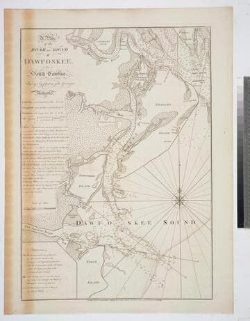
A Plan of the River and Sound of D'Awfoskee, in South Carolina. Survey'd by Captain John Gascoigne
Visual Materials
MS note: c 36. Prime meridian: London. Relief: no. Graphic Scale: Miles. Projection: Plane. Watermark: Crowned fleur-di-lis VI. Printing Process: Copper engraving. Verso Text: MS note: 349 10.
105:349 M

New Map of the West Indian Islands, as they are Possessed by the European Powers
Visual Materials
Kashnor ontes, "Indicates the English, Dutch, French, and Spanish possessions." Cartouche: branches.. "Drawn from the most Recent Authorities." Prime meridian: London. Relief: pictorial. Graphic Scale: Leagues. Projection: Cylindrical. Watermark: Crowned fleur-di-lis VI. Printing Process: Copper engraving. Other Features: Cartouche. Verso Text: MS note: 966.
105:966 M