Visual Materials
Atlantic Ocean By Governor Pownall F.R.S
You might also be interested in

Atlantic Ocean by Governor Pownall F.R.S
Visual Materials
Kashnor notes, "From the latitude of Iceland to that of Brazil, showing the coasts of the United States, and indicating the course of the Gulf Stream, and the various routes pursued by navigators, shoals, breakers, &c. A celebrated chart, and probably one of the best ever made. With inset elevations of mountains, capes, &c. One of the earliest maps issued in England to show the United States on the map of America." Views of mountains & capes on islands. Compass rose.. Prime meridian: Ferro. Relief: no. Projection: Mercator. Watermark: Crowned seal. Printing Process: Copper engraving. Other Features: Vignettes. Verso Text: MS note: 167.
105:167 M
Image not available
New General Chart of the Atlantic or Western Ocean and Adjacent Seas, Including the Coasts of Europe and Africa From 60 Degrees North Latitude to the Equator, and also the Opposite Coast of America; Drawn and Regulated by the most accurate Astronomical Observations, and the Journals of the most experienced Navigators; in which also are particularly distinguished the Determination of the Longitude as given by the Marine Clocks of Mr. Ferdinand Berthoud, in the Voyage performed by order of the Government of France, in 1768 and 1769 in the Ship Isis, to the Azores, Madera, the Canaries, Cape-Verd Islands, St. Domingo, the Great Bank of Newfoundland, &ca. by Mr. de Fleurieu, an Officer in the French Navy, and Member of the Royal Marine Academy, &ca
Visual Materials
Kashnor notes, "Shows the American Coast from Hudson's Strait to the Mouth of the Amazon, and gives a particularly good chart of Nova Scotia and West Indies." Lengthy explanation of preparation of this chart lower right.. Prime meridian: London, Ferro. Relief: no. Projection: Mercator. Watermark: Crowned fleur-di-lis VI. Printing Process: Copper engraving. Verso Text: MS notes: 276 Chart of the Atlantic, Northern part -- Southern part 66.
093:276 M

Island of Cuba with part of the Bahama Banks & the Martyrs. By Thos. Jeffereys, Geographer to his Majesty
Visual Materials
Kashnor notes, "Includes an accurate map of the adjacent seas, with soundings." Prime meridian: London, Ferro. Relief: pictorial. Projection: Mercator. Watermark: Crowned fleur-di-lis VI. Printing Process: Copper engraving. Verso Text: MS notes: 378 Island of Cuba & Bahama Banks.
105:378 M
Image not available
New Map of Nova Scotia, and Cape Breton Island with the adjacent parts of New England and Canada, Composed from a great number of actual Surveys; and other material Regulated by many new Astronomical Observations of the Longitude as well as Latitude; by Thomas Jefferys, Geographer to the King
Visual Materials
See map 093:269M for earlier edition. Note border change. Prime meridian: Ferro. Relief: pictorial. Projection: Conic. Watermark: Crowned fleur-di-lis VI. Printing Process: Copper engraving. Other Features: Cartouche. Verso Text: MS note: 270 34.
093:270 M
Image not available
2e. Carte de l'Asia. 1755
Visual Materials
Kashnor notes, "This is Palairet's map. It shows the Philippine Islands." MS note: 9 (upper right). Prime meridian: Ferro. Relief: pictorial. Graphic Scale: Miles, leagues, wersts, parasanges.. Projection: Azimuthal. Watermark: Crowned fleur-di-lis VI. Printing Process: Copper engraving. Verso Text: MS notes: 741 9.
105:741 M
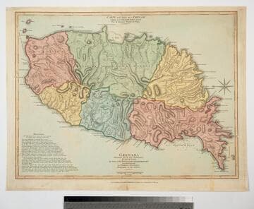
Grenada Divided into its Parishes, Surveyed By Order of His Excellency Governor Scott, and Engraved by Thomas Jefferys Geographer to the King
Visual Materials
Includes "Observations" on the island including "The Dotted Line along the Coast denotes the Fifty Paces belonging to the King." See also 093:767M for an earlier copy. Prime meridian: London, Ferro. Relief: hachures. Graphic Scale: Feet, leagues. Projection: Cylindrical. Watermark: Crowned fleur-di-lis VI. Printing Process: Copper engraving. Verso Text: MS notes: 768.
093:768 M