Rare Books
Map of the Burnt District of San Francisco, Showing the Extent of the Fire

You might also be interested in
Image not available
Map of the burnt district of San Francisco : showing the extent of the fire
Visual Materials
Printer: Fishbourne, R.W, 1836-1862, San Francisco (Calif.). Printer: Gower, S.J., San Francisco (Calif.)
priJLC_TRAV_006056
![View of the Conflagration from Telegraph Hill San Francisco, Night of May 3rd 1851. [upper] Map of Burnt District of San Francisco. [lower]](/_next/image?url=https%3A%2F%2Frail.huntington.org%2FIIIF3%2FImage%2F22APN4KXYIM9%2Ffull%2F%5E360%2C%2F0%2Fdefault.jpg&w=750&q=75)
View of the Conflagration from Telegraph Hill San Francisco, Night of May 3rd 1851. [upper] Map of Burnt District of San Francisco. [lower]
Rare Books
Upper image is of a scene with roaring fire in the city and burning ships in the harbor. Lower image is a map of the area from Pine St. to Vallejo St. (left to right) and Dupont St. to Battery St. (top to bottom). The map indicates the location of four grounded ships as well as buildings that were saved. Upside-down stamp in lower right corner below image. Paper color: gray.
48052:072

Diagram of the Burnt District
Rare Books
Upper part of sheet contains a map of the Sacramento area from H St. to L St. (top to bottom) and from Front Street to 8 St. (left to right) with most of twelve block blacked out. The text below the map describes the fire and lists the sufferers. The text notes that this is not the fire of November 2nd, 1852, but a later one. "Published at the Union Office, 21 J street, Sacramento."--text, below image. Paper color: blue.
48052:083

Map of the Burnt District
Rare Books
Image is a detailed map showing from California Str. to Broadway (left to right) and Mason Str. to Sansom [sic] (top to bottom). The map indicates the location of buildings that were saved from the fire. Baird notes that this sheet probably went, originally, with "View of the Conflagration...June 22nd." Or it may be part of a different edition of "View of the Conflagration...June 22nd." Paper color: gray.
48052:073

The only correct & fully complete Map of San Francisco...By Alex Zakreski, 1854
Rare Books
Image is of an early map of San Francisco with twenty-three letter references on the map. Twelve of these refer to public buildings and thirteen refer to churches. To the left and right of the map are eight vignettes, each depicting different buildings in the city such as City Hall and a Congregational Church. "Drawn & Lith. by Alex: Zareski, Cor. Washington & Montgomery Streets, at his Topographical Office. For sale by Cooke, Kenny & Co. Stationers, Montgomery Street, Cor. of Merchant."--text, below title of the map. Paper color: buff.
48052:042
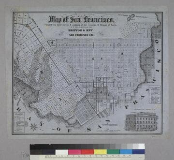
Map of San Francisco
Rare Books
Image is of a map of the downtown area with a vignette of Parrott Block in the lower right corner. The map covers the area from waterfront to Webster, and from North Point to Addition of Mission. At the lower left are nine letter identifications of public buildings on the map and symbols for other locations. At the right are twelve letter identifications for places of worship. "Published by Britton & Rey, San Francisco Cal."--text, below title of map. "Page Bacon & Co. Adams & Co."--text, above vignette in lower right corner. Paper color: blue.
48052:138