Rare Books
The only correct & fully complete Map of San Francisco...By Alex Zakreski, 1854

You might also be interested in
![[Map of San Francisco with Horners Addition.]](/_next/image?url=https%3A%2F%2Frail.huntington.org%2FIIIF3%2FImage%2F22APN4RLXZ8L%2Ffull%2F%5E360%2C%2F0%2Fdefault.jpg&w=750&q=75)
[Map of San Francisco with Horners Addition.]
Rare Books
"Subdivision of blocks in 'H.A.' [Horners Addition] as per map made for John M. Horner by J.J. Gardiner, City & Co. Surveyor, A.D. 1854 on January 1st.": ms. map on sheet 20 x 25.5 cm., mounted on lower half of lithographed map"For particulars refer to large map at J. M. Horners Office, Armory Hall, Montgomery St." MS notes: Map of Horners addition Rancho de San Miguel or Noe Rancho. A copy of this map filed at the request of A. C. Thayer Nov 11, 63, 22 min past 10 O'clock. Rbbs 173 to 180 are now located on the new maps of the City.... Prime meridian: GM. Relief: no. Graphic Scale: Feet. Projection: Cylindrical. Printing Process: Lithography. Verso Text: MS notes: 442362 Horners Addition.
442362
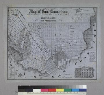
Map of San Francisco
Rare Books
Image is of a map of the downtown area with a vignette of Parrott Block in the lower right corner. The map covers the area from waterfront to Webster, and from North Point to Addition of Mission. At the lower left are nine letter identifications of public buildings on the map and symbols for other locations. At the right are twelve letter identifications for places of worship. "Published by Britton & Rey, San Francisco Cal."--text, below title of map. "Page Bacon & Co. Adams & Co."--text, above vignette in lower right corner. Paper color: blue.
48052:138
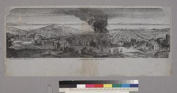
San Francisco, 1854. Fire of July 11th
Rare Books
Image is of the general view of San Francisco from Nob Hill looking east with Yerba Buena Island in the background. Part of the city is in flames (Jackson Street, as Baird notes). There are several figures in the foreground viewing the fire. "Lith. of Britton & Rey Cor Montg. & Comm. Sts."--text, below image. Paper color: gray. Baird notes that this image is a variant state of the stone used for "San Francisco, 1854."
48052:049

San Francisco, 1854
Rare Books
Image is of the general view from Nob Hill area looking east with Yerba Buena Island in the background. Two figures are standing on the hill in the foreground and an artist is sketching. Baird notes that although this image is apparently not the same stone, it is the same basic view as "San Francisco Upper California." "[Britton] & Rey Cor. Montgy. & Comml. Sts."--text, below image. "Noisy Carrier's Publishng [Hall]. 77 Long Wharf San Francisco. Charles P. Kimball Propretor [sic]."--stamped text, below image to the right. Paper color: gray.
48052:117

San Francisco In 1851
Rare Books
Image is of the view from the west to Yerba Buena Island, harbor, and bay. Telegraph Hill and station are at the left. "From Nature and on Stone, by J.H. Peirce. Published by Cooke & LeCount Booksellers & Stationers Montgomery Street, Wells Building. Printed by Chas. E. Per[egoy]."--text, below image. Paper color: gray.
48052:135

Map of the Burnt District of San Francisco, Showing the Extent of the Fire
Rare Books
Image contains a map showing the area from Pine Street to Vallejo Street (left to right) and from Front Street to Dupont Street (bottom to top). The darkened portions of the map indicate where the fire was. There are fifty-four numbered destroyed buildings on the map, and twenty-three lettered saved buildings. Below the map is a key for these labeled buildings, indicating the occupants and material used in their construction. "S.J. Gower del. Fishbourne's Lithog. Ohio Street, San Francisco."--text, below map. Paper color: gray.
48052:122