Rare Books
[Map of San Francisco with Horners Addition.]

You might also be interested in
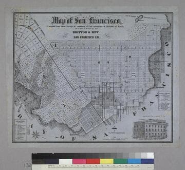
Map of San Francisco
Rare Books
Image is of a map of the downtown area with a vignette of Parrott Block in the lower right corner. The map covers the area from waterfront to Webster, and from North Point to Addition of Mission. At the lower left are nine letter identifications of public buildings on the map and symbols for other locations. At the right are twelve letter identifications for places of worship. "Published by Britton & Rey, San Francisco Cal."--text, below title of map. "Page Bacon & Co. Adams & Co."--text, above vignette in lower right corner. Paper color: blue.
48052:138
Image not available
A map of the town of San Francisco 1847
Rare Books
Accompanied by a document stating," I hereby certify that this map is a true photographic copy of the first map of San Francisco on file at the office of the Recorder. [signed] Eugene J. Sullivan, Deputy Recorder, January 4, 1905." A manuscript map laid on linen. Unreadable MS notes. Accompanying document has pencil drawn heads both sides. Prime meridian: GM. Relief: no. Projection: Plane. Printing Process: Photo reproduction.
71001
Image not available
Map of the Bay of San Francisco and the gold regions in California / by P. Holley
Rare Books
An MS note says printed in 1849 but details indicate a later publication date. OPAC note suggests map is similar to Jarves 1849 map, Wheat 100. It is not. Note Lake Tahoe [unnamed] on this map which did not appear on maps of that era. MS notes: This map was printed in 1849. x77475 NC. Prime meridian: GM. Relief: shaded. Projection: Cylindrical. Printing Process: Lithography. Verso Text: MS notes: Gold Regions '49 774.
77475
Image not available
Official Map of the City of San Francisco
Rare Books
Varnished map, be careful. Street railway lines colored by hand. Prime meridian: GM. Relief: no. Graphic Scale: varies. Projection: Plane. Printing Process: Lithography. Verso Text: MS note: Early map of S.F. 263314 4.
263314
Image not available
Map of the City of San Francisco
Rare Books
Map was published in Colville's Directory, volume 1 (see RB 65016). Shows original shoreline and considerable fill already accomplished. Submap shows San Francisco County extending half way to San Jose. Submap: County of San Francisco. MS note: X71002. Prime meridian: GM. Relief: no. Graphic Scale: Varies. Projection: Plane. Printing Process: Lithography. Verso Text: MS note: About 1852 $14.00.
71002
Image not available
Map of San Francisco 1854
Visual Materials
Reproduction. No old shelf mark. Verso contains a copy of a letter from A.L. Bancroft & Co. Map Publishing Dept. offering services. Prime meridian: GM. Relief: no. Projection: Plane. Printing Process: Lithography. Verso Text: MS letter copy.
ephMPCALIF0132