Rare Books
A map of the town of San Francisco 1847
You might also be interested in
Image not available
MacLean & Lawrences sectional map of Kansas Territory : compiled from the U.S. survey's / by C.P. Wiggin
Rare Books
Alt. title from cover. "I hereby certify that the above Map was compiled from the field notes of those surveys on file in this office, L. A. MacLean, Chief Clerk, Surveyor General Office, Lecompton, K.T. April 1857." Prime meridian: Washington. Relief: hachures. Graphic Scale: Sections. Projection: Cylindrical. Printing Process: Lithography.
41391
Image not available
Official map of the Territory of Arizona : with all the recent explorations / compiled by Richard Gird C.E. Commissioner
Rare Books
The Territory includes the southern part of Nevada, including Las Vegas, and much "unexplored territory." "We hereby certify that this is the Official Map of the Territory of Arizona and approve the same. Prescott, Oct. 12, 1865. John N. Goodwin, Governor." Prime meridian: GM. Relief: hachures. Graphic Scale: Miles. Projection: Polyconic. Printing Process: Lithography. Verso Text: MS note: 41436.
41436
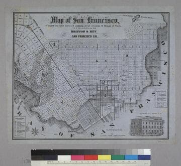
Map of San Francisco
Rare Books
Image is of a map of the downtown area with a vignette of Parrott Block in the lower right corner. The map covers the area from waterfront to Webster, and from North Point to Addition of Mission. At the lower left are nine letter identifications of public buildings on the map and symbols for other locations. At the right are twelve letter identifications for places of worship. "Published by Britton & Rey, San Francisco Cal."--text, below title of map. "Page Bacon & Co. Adams & Co."--text, above vignette in lower right corner. Paper color: blue.
48052:138
Image not available
Untitled manuscript beginning, "We hereby certify..."
Manuscripts
This untitled manuscript reads, "We hereby certify that Ebenezer Darling exercises the privilege of a freeman by voting in Ryegate last year and [---- ----?] still a freeman of Ryegate with undoubted right to exercise the same privilege this year." The manuscript is signed by James Hall, James R. Park, and Archibald Park.
mssHM 80242
Image not available
Official map of San Bernardino County, California : compiled from latest official maps of U.S. surveys, railroad and irrigation surveys, county records, and other reliable sources / & drawn by T.D. Beasley
Rare Books
See RB 477777 for a map of the Southwest portion of San Bernardino County. Submaps shows claims in mining distrcts. "We the members of the Board of Supervisors of San Bernardino County California, hereby adopt this map as the Official Map of said County. San Bernardino, May 18th, 1892." Submaps: Mining districts of Calico, Holcomb Valley, Bear Valley, Clark, Ord Mountain, Trojan with claims. Prime meridian: Gm. Relief: hachures. Graphic Scale: Miles. Projection: Cylindrical. Printing Process: Lithography.
477787
![[Map of San Francisco with Horners Addition.]](/_next/image?url=https%3A%2F%2Frail.huntington.org%2FIIIF3%2FImage%2F22APN4RLXZ8L%2Ffull%2F%5E360%2C%2F0%2Fdefault.jpg&w=750&q=75)
[Map of San Francisco with Horners Addition.]
Rare Books
"Subdivision of blocks in 'H.A.' [Horners Addition] as per map made for John M. Horner by J.J. Gardiner, City & Co. Surveyor, A.D. 1854 on January 1st.": ms. map on sheet 20 x 25.5 cm., mounted on lower half of lithographed map"For particulars refer to large map at J. M. Horners Office, Armory Hall, Montgomery St." MS notes: Map of Horners addition Rancho de San Miguel or Noe Rancho. A copy of this map filed at the request of A. C. Thayer Nov 11, 63, 22 min past 10 O'clock. Rbbs 173 to 180 are now located on the new maps of the City.... Prime meridian: GM. Relief: no. Graphic Scale: Feet. Projection: Cylindrical. Printing Process: Lithography. Verso Text: MS notes: 442362 Horners Addition.
442362