Rare Books
View of the Conflagration from Telegraph Hill San Francisco, Night of May 3rd 1851. [upper] Map of Burnt District of San Francisco. [lower]

You might also be interested in
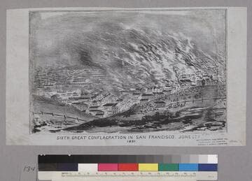
Map of the Burnt District Sixth Great Conflagration in San Francisco. June 22nd 1851
Rare Books
Image is a view of the harbor and town from Telegraph Hill. The town is burning at right, the harbor full of ships is at left, and crudely-drawn people are on the hill in the foreground. Baird notes that this is a reworking of the "View of the Conflagration...May 3rd 1851." "J. De Vere del."--text, below image. "Noisy Carrier's Publishing Hal[l]. 77 Long Wharf San Francisco. Charles P. Kimball Propretor [sic]."--stamped text, lower right corner. Paper color: gray. This is only the illustration; the portion of the sheet containing a map of the burnt district is missing (according to Baird's notes).
48052:134
![San Francisco, 1858. [upper] San Francisco. 1849 & 1850. From Telegraph Hill. [lower]](/_next/image?url=https%3A%2F%2Frail.huntington.org%2FIIIF3%2FImage%2F22APN4KXUT3Q%2Ffull%2F%5E360%2C%2F0%2Fdefault.jpg&w=750&q=75)
San Francisco, 1858. [upper] San Francisco. 1849 & 1850. From Telegraph Hill. [lower]
Rare Books
Upper image is a view from the Plaza, exactly the same as "San Francisco 1854." "Lith. of Britton & Rey Cor. Montg & Comm. Sts."--text, below image. Lower image is a view looking south from Telegraph Hill with the Plaza near the center, wharves and ships to the left, and two or three streets of buildings to the right. Baird notes that this image is apparently based on Swan's "View of San Francisco, From Telegraph Hill." Paper color: blue.
48052:113

Map of the Burnt District of San Francisco, Showing the Extent of the Fire
Rare Books
Image contains a map showing the area from Pine Street to Vallejo Street (left to right) and from Front Street to Dupont Street (bottom to top). The darkened portions of the map indicate where the fire was. There are fifty-four numbered destroyed buildings on the map, and twenty-three lettered saved buildings. Below the map is a key for these labeled buildings, indicating the occupants and material used in their construction. "S.J. Gower del. Fishbourne's Lithog. Ohio Street, San Francisco."--text, below map. Paper color: gray.
48052:122

Diagram of the Burnt District
Rare Books
Upper part of sheet contains a map of the Sacramento area from H St. to L St. (top to bottom) and from Front Street to 8 St. (left to right) with most of twelve block blacked out. The text below the map describes the fire and lists the sufferers. The text notes that this is not the fire of November 2nd, 1852, but a later one. "Published at the Union Office, 21 J street, Sacramento."--text, below image. Paper color: blue.
48052:083

Plan of the Burnt District, Sacramento, Showing the Buildings which escaped
Rare Books
Image is of a map from the levee to 7th St. (left to right) and from I St. to L St. (top to bottom). The Sacramento River is labeled at the far left, and Sutter Lake is labeled at the top. The blacked out portion of the map indicates where the fire occurred. Baird notes that this map is said to refer to the fire of July 13th, 1854. "Published by barber & Baker."--text, below image. "Noisy Carriers, San Francisco."--stamped text, upper right corner of image. Paper color: gray.
48052:088
Map of San Francisco
Rare Books
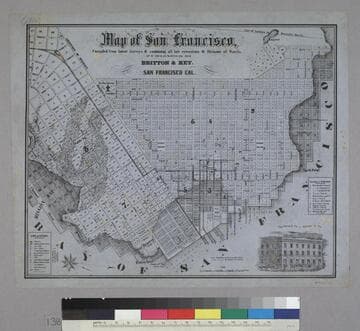
Image is of a map of the downtown area with a vignette of Parrott Block in the lower right corner. The map covers the area from waterfront to Webster, and from North Point to Addition of Mission. At the lower left are nine letter identifications of public buildings on the map and symbols for other locations. At the right are twelve letter identifications for places of worship. "Published by Britton & Rey, San Francisco Cal."--text, below title of map. "Page Bacon & Co. Adams & Co."--text, above vignette in lower right corner. Paper color: blue.
48052:138