Visual Materials
Our country
You might also be interested in
Image not available
Rambles through our country : an instructive geographical game for the young
Visual Materials
Image of a pictorial map of the United States used as an interactive game board. Regional landmarks and natural features of each state are illustrated with simplistic and exaggerated imagery (i.e. waterfalls, mountains, wild animals, government buildings, foliage). Specific areas on the map are numbered. The print has two vignettes, one on the upper right corner which depicts the Statue of Liberty, an American Eagle and American flags next to text that reads, "The Rising Generation." Another vignette located on the bottom left corner of the print depicts a dramatized image of four indigenous people holding rifles while hiding out amongst trees on a hill watching over a train that passes by below. Bodies of water are shown bordering the map, illustrated with sails and ferries.
priJLC_SPO_005003
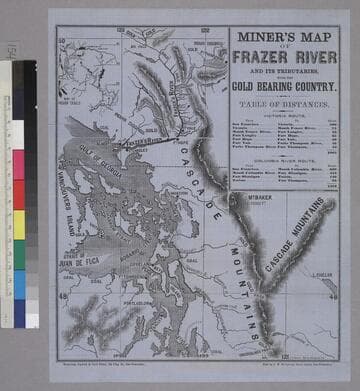
Miner’s Map of Frazer River and it’s Tributaries With the Gold Bearing Country
Rare Books
Image is a topographical map of the area from Snoqualmoo Pass in the southeast to Big Falls in the north, and from Vancouvers Island in the west to L. Chelan in the east. Notable features on the map include the Gulf of Georgia, Puget Sound, Frazer's River, and the Cascade Mountains. Locations of coal, gold, digging sites, and Indian diggings are labeled on the map. In the upper right corner is a table of distances, and in the upper left corner is a map of Indian trails. "Whitton, Towne & Co's Print, 125 Clay St., San Francisco. Sold by J. W. Sullivan, News Agent, San Francisco. S. F. Baker. Engr. 159 Clay St."--text, below image. Paper color: blue.
48052:154
![View of the Conflagration from Telegraph Hill San Francisco, Night of May 3rd 1851. [upper] Map of Burnt District of San Francisco. [lower]](/_next/image?url=https%3A%2F%2Frail.huntington.org%2FIIIF3%2FImage%2F22APN4KXYIM9%2Ffull%2F%5E360%2C%2F0%2Fdefault.jpg&w=750&q=75)
View of the Conflagration from Telegraph Hill San Francisco, Night of May 3rd 1851. [upper] Map of Burnt District of San Francisco. [lower]
Rare Books
Upper image is of a scene with roaring fire in the city and burning ships in the harbor. Lower image is a map of the area from Pine St. to Vallejo St. (left to right) and Dupont St. to Battery St. (top to bottom). The map indicates the location of four grounded ships as well as buildings that were saved. Upside-down stamp in lower right corner below image. Paper color: gray.
48052:072

Canadian Pacific railway and steamships span the World : bridging two oceans and linking four continents
Visual Materials
The map is within a printed frame, the title is printed above and below this frame; in the left corner above the frame is an image of the Spirit of the Pacific and in the right corner is an image of the Spirit of the Atlantic, sculptures by Isidore Konti from the 1904 World's Fair (Louisiana Purchase Exposition) which marked the 100th anniversary of the Louisiana Purchase. "Copyright, 1923, in Canada and the United States by the Candian Pacific Railway / Engraved and printed at the Matthews-Northrup Works, Buffalo, N.Y."--text, small type, lower left corner of the map. Poster backed by linen and is tacked onto two wood dowels; meant to hang as a wall map. "C.P.R. World Map"--on verso, in ms., in pencil.
priJHK 00115

The short line across the continent. : Map of the great central route between the Atlantic and Pacific : Michigan Central and Great Western Railways
Visual Materials
Image of a map of a portion of the Eastern United States from as far west as Omaha, Nebraska, showing railroad routes of the Michigan Central and Great Western Railroad and connecting lines, with a vignette in the lower left corner of the Niagara Falls Suspension Bridge and an inset map in the lower right corner of the Western United States showing railroad routes and titled, "Map between the Missouri River and the Pacific Ocean"; map verso contains panels with the fold-up map covers, promotional descriptions including an image of a freight car for the Great Central Route's Blue Line, and timetables.
priJLC_TRAN_001174

A map showing the network of European railroads
Visual Materials
"[Affixed label for D.F. Robertson Travel Insurance] through all Europe from Paris ... via French National Railroads"--text box with an image of the Eiffle Tower and train, the outline of France in green in the background, upper right corner of the map. "Printed in U.S.A., Z.J. Kantin Company, N.Y."--text, small type, lower left corner, below image. "Specially prepared by the French National Railroads / offered to travel agents — A.S.T.A. Convention — 1949"--text, lower right corner, below image. Two labels for D.F. Robertson Travel Insurance, Los Angeles, are affixed to the map, one along the lower edge, the other in blank space left for an agent's, or agencies, stamp in the upper right corner of the map within the inset text box.
priJHK 00118