Visual Materials
A map showing the network of European railroads

You might also be interested in
Image not available
A map showing the network of European railroads
Visual Materials
Artists: E.G. Publishers: Z.J. Kantin Company Companies: Société nationale des chemins de fer français.
priJHK 00118

A good-natured map of Alaska showing the services offered by "The Alaska Line" and suggesting some of the most interesting features of the Territory
Visual Materials
Title from cartouche. "Copyrighted, 1940 by Alaska Steamship Company, Pier 9, Seattle"--text, small type, lower left corner of map. "Lithographed in U.S.A. Farwest Lithograph & Printing Co., Seattle"--text, small type, lower right corner, margin.
priJHK 00078

La Bretagne Pittoresque
Visual Materials
"Roscoff : Le Port"--alt title, above artist's signature, lower right corner of image. "Constant Duval"--artist's signature, lower right corner of image. "Chemins de fer de l'État"--printed above the image in large white text on blue background. "Atelier Constant Duval, 19, Via Chaptal, Levaillois (Seine)"--text, small type in white, lower margin, left corner. "Printed in France"--text, small type in light blue, lower margin center. "Imp. Champenois, 66, Bould. St. Michel, Paris"--text, small type in white, lower margin, right corner. "Affiche a apposer dans les gares ou bureaux de ville gérés directement par les agents des Chemins de fer de l'État"--stamp in green ink, small type, upper right corner of the image.
priJHK 00048
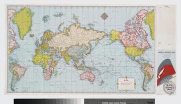
APL World cruise map
Visual Materials
Along right side of map is space to right out a travel itinerary, and below it a graphic of APL vessel stack; map was once folded and the right side would form the back and front covers of the folded map. "ADV WM2 100M 10-58"--text, small type, in space between itinerary and graphic. "[1958/9]"--in ms., in pencil, lower right corner.
priJHK 00117

Polska Karpaty : Polskie Koleje Państw = The Carpathians Poland : Polish State Railways = Les Carpathes Pologne : Chemins de Fer de l'Etat = Polen Karpathen : Polnische Staatsbahnen
Visual Materials
Map in inset centered below main image shows pre-Second World War Poland with rail lines is red; Tatarów is identified in the lower right of the map. "Wład. Jarocki"--artist's signature reproduced in image, lower right corner. "Druk offsetowy Lit. A. Pruszyński, Kraków"--text in margin, lower right corner. "Printed in Poland - Drukawano w Polsce"--text, printed smaller type, in margin, lower left corner. "Travel to Poland on the express ships of the Cunard Line / Berengaria Aquitania Mauretania"--text on a strip pasted onto the bottom of the poster. Tatarów became part of the Ukraine following the Second World War, now known as Tatariv. Same poster as ephKMEpos 00033, however this copy has not been trimmed along the bottom edge.
priJHK 00032
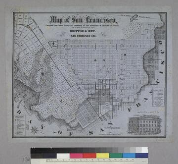
Map of San Francisco
Rare Books
Image is of a map of the downtown area with a vignette of Parrott Block in the lower right corner. The map covers the area from waterfront to Webster, and from North Point to Addition of Mission. At the lower left are nine letter identifications of public buildings on the map and symbols for other locations. At the right are twelve letter identifications for places of worship. "Published by Britton & Rey, San Francisco Cal."--text, below title of map. "Page Bacon & Co. Adams & Co."--text, above vignette in lower right corner. Paper color: blue.
48052:138