Visual Materials
Plan of Boston and its Environs during the true Situation of His Majesty's Army. and also those of the Rebels

You might also be interested in

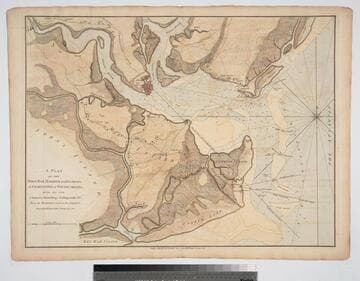
Attack of the Rebels upon Fort Penobscott in the Province of New England in which their Fleet was totally destroyed and their Army dispersed the 14th. Augst. 1779. For the Continuation (after Tindal's) of Rapin's History of Egd. Published as the Act directs Decr. 18th 1785. by an Officer present
Visual Materials
Kashnor notes, "This is the war plan of Commodore Saltonstall's attack on Fort Penobscott, who is shown to have retired up the river and destroyed his fleet to prevent capture." Text covers description of battle where British forces prevailed and a large rebel contingent of ships was burned to save them from falling into British hands. Place of publication conjectured. MS note: 97. Relief: hachures. Graphic Scale: Yards. Projection: Plane. Watermark: Crowned fleur-di-lis. Printing Process: Copper engraving. Verso Text: MS note: 97.
093:097 M
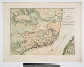
Plan of the City and Environs of Quebec with its Siege and Blockade by the Americans, from the 8th of December 1775 to the 13th of May 1776
Visual Materials
Kashnor notes, "A very fine war plan, in colours, showing where Montgomery made his attack and the emplacement of batteries." A stunning map. Kershaw supplies appeared in information. Relief: hachures. Graphic Scale: Yards. Projection: Plane. Watermark: Crowned fluer-di-lis W F. Printing Process: Copper engraving. References: Kershaw 1041; LC Phillips 1207,1337.. Verso Text: MS note: 120.
093:120 M

Plan of the Operations of the King's Army under the Command of General Sr. William HoWe, K.B. in NeW York and East NeW Jersey, against the American Forces Commanded by General Washington, From the 12th. of October, to the 28th. of November 1776
Visual Materials
Kashnor notes, "An exceedingly rare plan of one of the most famous engagements during the American Revolution." Relief: hachures. Graphic Scale: Miles. Projection: Plane. Watermark: CroWned fleur-di-lis W F. Printing Process: Copper engraving. Verso Text: MS notes: 109 JS.
093:109 M
Plan of the Town, Bar, Harbour and Environs, of Charlestown in South Carolina, with all the Channels, Soundings, Sailing-marks &c. From the Surveys made in the Colony Engraved by William Faden, Charing Cross, 1780
Visual Materials
Kashnor notes, "A very scarce plan issued for use during the American Revolution." Atlas reference from The American Revolution 1775-1783, Naval History Division, Department of the Navy, Washington, 1972. Huntington f G1202 S3U5. Compass Rose. Relief: hachures. Graphic Scale: Miles. Projection: Cylindrical. Watermark: Crowned fleur-di-lis. Printing Process: Copper engraving.
093:082 M

Plan of Cape Fear River from the Bar to Brunswick
Visual Materials
Kashnor notes, "A rare chart issued for use during the American Revolution." Shows Fort Johnston and harbor. Gives sailing directions for entering Cape Fear River. Prime meridian: London. Relief: pictorial. Graphic Scale: Leagues, miles. Projection: Cylindrical. Watermark: Crowned fleur-di-lis. Printing Process: Copper engraving. Verso Text: MS note: 78.
093:078 M

North America from the French of Mr. D'Anville improved with the English Surveys made Since the Peace
Visual Materials
Kashnor notes, "An interesting map, showing parts of Canada, with Newfoundland, and Nova Scotia, and the United States east of the Mississippi." Prime meridian: London, Ferro. Relief: pictorial. Graphic Scale: Miles, English, sea leagues. Projection: Pseudocylindrical. Watermark: Crowned fleur-di-lis W I. Printing Process: Copper engraving. Other Features: Cartouche. Verso Text: MS note: 114.
093:114 M