Rare Books
The Goa's map genal transcribed and casticationed

You might also be interested in
Image not available
Mappe Monde Carte Universelle de la Terre Dresée Sur les Nouvelles Observations de Mrs. de l'Académie Royale des Sciences
Visual Materials
Kashnor notes, "Shows a good coast of the North-West, locating the Russian discoveries of 1744." Depicts rudimentary Mer de l'Ouest. Cartouche with ribbon border. Fallen warrior and signs of battle below map, armillary sphere.. Prime meridian: Ferro. Relief: no. Graphic Scale: No. Projection: Dual Hemisphere. Watermark: Undecipherable lettering. Printing Process: Copper engraving. Other Features: CartoucheVignettes. Verso Text: MS note: 36.
105:036 S
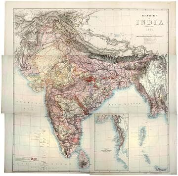
Railway map of India
Rare Books
Kirkpatrick Catalogue entry: "2493 [India. Survey of India Dept.] Railway map of India. [Calcutta, 1885]. 6 sheets. [see cabinet]." Submap: Continuation of the Province of Nritish Rurmah (Tenasserim Division) MS notes: Burton (map cabinet) India Railway . Prime meridian: GM. Relief: hachures. Graphic Scale: Miles. Projection: Polyconic. Printing Process: Lithography. Other Features: Sub-maps.
623667

Map of Uganda and adjoining territories : compiled for the Intelligence Division, War Office / by Captain J.R.L. Macdonald, R.E
Rare Books
Kirkpatrick Catalogue entry: "2444 Macdonald, J.R.L. Map of Uganda and adjoining territories compiled for the Intelligence Division, War Office. London, Edward Stanford, 1895. 1 sheet. [see cabinet]." MS notes: Burton (map cabinet) Macdonald. Prime meridian: GM. Relief: shaded. Graphic Scale: Miles. Projection: Cylindrical. Printing Process: Lithography.
623618

Mappa do territorio Portuguez de Goa : dedicado a rainha de Portugl. D. Maria de Gloria, extrahido d'original, dezenho., e lithographado / por Joze Maria Gonsalves, Natural de Piedade d'Ilha Opiuar, Primeiro Dexenhador n'Officina do Engenheiro Mor em Bombaim
Rare Books
Kirkpatrick Catalogue entry: "2488 Gonsalves, J. M. Mappa do territorio portuguez de Goa ... extrahido d'original ... Bombaim, [187-]]. 1 sheet. [see p.]."Missing lower left portion of this map. Small view of a cathedral in the lower right. It's description has been crossed out and replaced with a hard to read note. Queen Maria II of Portugal, to whom the map is dedicated, reigned from 1826-1828 and 1834-1853. Cartouche: Village scene. MS notes: RB 11492S Stamp: Kensington Public Libraries. Prime meridian: GM. Relief: hachures. Graphic Scale: Miles. Projection: Cylindrical. Printing Process: Lithography. Other Features: Cartouche. Verso Text: MS notes: Goa maps Gonsalves. Sticker: RB 11492 S Stamp: Kensington Public Libraries.
623662
Image not available
Map of the Pamirs and adjacent territory
Rare Books
Kirkpatrick Catalogue entry: "2489 Great Britain. War Office. Intelligence Division. Map of the Pamirs and adjacent territory. London, Edward Stanford for the War Office, 1893. 1 sheet. [see cabinet]."Appeared in "Map of the country between Russian and Chinese Turkestan and British India. Compiled in the Intelligence Division, War Office, mainly from the Latest India Survey and Russian General Staff Maps under the Direction of Lt. Col. Y.C. Dalton."? MS notes: Burton (map cabinet) Great Britain War Office 2489.. Prime meridian: GM. Relief: hachures. Graphic Scale: Miles. Projection: Polyconic. Printing Process: Lithography.
623663

New Map of the World from the latest Observations, revis'd by J. Senex
Visual Materials
Kashnor notes, "Shows the Strait of Anian and California as an Island, also New Holland, Van Diemen's Land, and part of New Zealand." Kashnor notes ca. 1719. Senex worked in London. Cartouche with angels and female figures. Two males below by armillary sphere. Four sub-maps, two on plane of Equator [polar views], two on the plane of London. one centered on London's antipode. Two depictions of climate zones.. Prime meridian: London. Relief: pictorial. Graphic Scale: No. Projection: Dual Hemisphere. Printing Process: Copper engraving. Other Features: CartoucheSub-mapsFigures . Verso Text: MS. notes: 93; 48; ~1719.
093:048 M