Rare Books
Map of Uganda and adjoining territories : compiled for the Intelligence Division, War Office / by Captain J.R.L. Macdonald, R.E

You might also be interested in
Image not available
Map of the Pamirs and adjacent territory
Rare Books
Kirkpatrick Catalogue entry: "2489 Great Britain. War Office. Intelligence Division. Map of the Pamirs and adjacent territory. London, Edward Stanford for the War Office, 1893. 1 sheet. [see cabinet]."Appeared in "Map of the country between Russian and Chinese Turkestan and British India. Compiled in the Intelligence Division, War Office, mainly from the Latest India Survey and Russian General Staff Maps under the Direction of Lt. Col. Y.C. Dalton."? MS notes: Burton (map cabinet) Great Britain War Office 2489.. Prime meridian: GM. Relief: hachures. Graphic Scale: Miles. Projection: Polyconic. Printing Process: Lithography.
623663
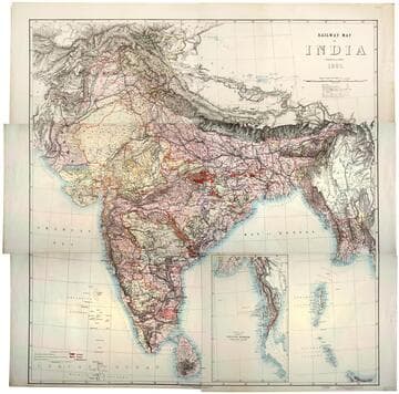
Railway map of India
Rare Books
Kirkpatrick Catalogue entry: "2493 [India. Survey of India Dept.] Railway map of India. [Calcutta, 1885]. 6 sheets. [see cabinet]." Submap: Continuation of the Province of Nritish Rurmah (Tenasserim Division) MS notes: Burton (map cabinet) India Railway . Prime meridian: GM. Relief: hachures. Graphic Scale: Miles. Projection: Polyconic. Printing Process: Lithography. Other Features: Sub-maps.
623667

Ordnance Survey of Jerusalem / by Captain Charles W. Wilson, R.E. under the direction of Colonel Sir Henry James, R.E. F.R.S. &c. Director of the Ordnance Survey
Rare Books
Kirkpatrick Catalogue entry: "2500 Wilson, C. W. Ordnance survey of Jerusalem ... under the direction of Colonel Sir Henry James ... 1864-5. Southampton, Ordnance Survey Office, 1876. 1 sheet. [see cabinet]."City divided into Jewish, Armenian, Christian, and "Mahometan" quarters. Prime meridian: GM. Relief: contour lines. Graphic Scale: Miles, kilometers, wersts, toises. Projection: Plane. Printing Process: Copper engraving. Verso Text: MS notes: Burton ((map cabinet) Wilson 2500.
623674

New original map of the island of Cyprus / by Henry Kiepert, Prof. Berlin Univ., M. R. Sc. Berlin, Hon. Corr. M. R. Geogr. Soc. of London
Rare Books
Kirkpatrick Catalogue entry: "2517 Kiepert, H. New original map of the island of Cyprus. Berlin, Dietrich Reimer; London, Williams & Norgate, 1878. 1 sheet. [see p.]."Some of the names on the map also have their Turkish or Ancient equivalent. Prime meridian: GM, Paris. Relief: shaded. Graphic Scale: Miles, kilometers. Projection: Cylindrical. Printing Process: Lithography. Verso Text: Label: paper MS notes: R.B. 11489J. 2517 Europe p maps Kiepert. Stamps: Kensingtonh Public Libraries.
623691

The East coast of Africa : including the islands of Zanzibar & Pemba / by Captn. A.T.E. Vidal, & the other officers of H.M.S. Barracouda & Albatross, under the orders of Captn. W.F.W. Owen. 1823-4
Rare Books
Kirkpatrick Catalogue entry: "2447 d Owen, W.F.W. The east coast of Africa, including the Islands of Zanzibar & Pemba, by Capt. A.T.E. Vidal, & the officers...under the orders of Captn. W.F.W. Owen, 1823-4. London, Admiralty, Hydrographical Office, 1828. 1 sheet. [see cabinet]."At head of title: "Sheet X." MS notes: 2447 d Burton (map cabinet) Owen East. Prime meridian: GM. Relief: hachures. Projection: Cylindrical. Printing Process: Lithography.
623621

Surveys of ancient Babylon and the surrounding ruins with part of the Rivers Tigris and Euphrates the Hindiyeh Canal the Sea of Nejf & the Shat Atshar : made by order of the Government of India in 1860 to 1865 / by Commander W. Beaumont Selby, and Lieutenant W. Collingwood and Lieutenant J. B. Bewsher, officers of Her Majesty's Indian Navy on Surveying Service the Nahrwan, Yusufiyeh, etc. added from surveys by Captain J. Felix Jones, I.N. compiled by order of H.M. Secretary of State for India in Council, by Trelawney Saunders, F.R.G.S. Geographical Assistant, India Office
Rare Books
Kirkpatrick Catalogue entry: "2496 Saunders, T., compiler. Surveys of ancient Babylon and the surrounding ruins ... made by order of the Government of India in 1860 to 1865 ... [by W. B. Selby, W. Collingwood, and J.B. Bewsher]. London, W. H. Allen, Edward Stanford, Trübner, 1885. 6 sheets. [see cabinet]."Large colorful map with sixteen black and white views of various cities, towns, forts, and ruins. Printed notes throughout map indicate geological and geographical features, points of archaeological and historical interest, and agricultural information. MS notes: Burton (map cabinet) Saunders Vignettes: Ruins. Prime meridian: GM. Relief: hachures. Graphic Scale: Miles, yards, stadia. Projection: Cylindrical. Printing Process: Lithography. Other Features: Vignettes.
623670