Rare Books
Map of the Pamirs and adjacent territory
You might also be interested in

Map of Uganda and adjoining territories : compiled for the Intelligence Division, War Office / by Captain J.R.L. Macdonald, R.E
Rare Books
Kirkpatrick Catalogue entry: "2444 Macdonald, J.R.L. Map of Uganda and adjoining territories compiled for the Intelligence Division, War Office. London, Edward Stanford, 1895. 1 sheet. [see cabinet]." MS notes: Burton (map cabinet) Macdonald. Prime meridian: GM. Relief: shaded. Graphic Scale: Miles. Projection: Cylindrical. Printing Process: Lithography.
623618
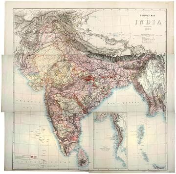
Railway map of India
Rare Books
Kirkpatrick Catalogue entry: "2493 [India. Survey of India Dept.] Railway map of India. [Calcutta, 1885]. 6 sheets. [see cabinet]." Submap: Continuation of the Province of Nritish Rurmah (Tenasserim Division) MS notes: Burton (map cabinet) India Railway . Prime meridian: GM. Relief: hachures. Graphic Scale: Miles. Projection: Polyconic. Printing Process: Lithography. Other Features: Sub-maps.
623667

Contour map of India
Rare Books
Kirkpatrick Catalogue entry: "2492 [India. Survey of India Dept.] Contour map of India. [Calcutta, 1886] 6 sheets. [see cabinet].""Based on a system of approximate contours." Two tables: "Table showing the Mean Elevation of India in different Latitudes" and "Table showing Lengths and Heights of Sources of the larger Rivers of India and the Areas drained by them." MS notes: Burton (map collection) India contour. Prime meridian: GM. Relief: contour lines. Graphic Scale: Miles. Projection: Polyconic. Printing Process: Lithography.
623666
Image not available
Maps
Manuscripts
13 printed maps with Francis Beaufort's annotations intended for publication by the Society for the Diffusion of Useful Knowledge (SDUK). The Society formed the Map Committee in November 1828, and Beaufort undertook the editing and annotation of the series for the next 15 years. Maps depict various areas of Great Britain, Europe, India and the Caribbean. 8 maps are missing as of April 2016. Available maps are identified below.
FB 974

Kronstadt north and south channels : from Russian surveys to 1867
Rare Books
Kirkpatrick Catalogue entry: "2513 [Great Britain. Admiralty.] Kronstadt north and south channels from Russian surveys to 1867. London, Admiralty, 1871. 1 sheet. At head of title: Gulf of Finland. [see cabinet]."At head of title: "Gulf of Finland." Several points marked with a red dot (lighthouses?). Submap: Kronstadt South Channel. MS notes: Burton Map cabinet Great -- Admiralty 2513. Prime meridian: GM. Relief: hachures. Projection: Cylindrical. Printing Process: Lithography. Other Features: Sub-maps.
623687
Image not available
A New and Accurate Map of North America
Rare Books
A version of Kitchin's map. Note South Carolina is split in two sections. Cartouche: framed with coat of arms. Sub map: Map of Hudsons Bay &c. MS note: 140842. "(wherein the Errors of all proceeding British, French, and Dutch Maps, respecting the rights of Great Britain, France & Spain, & the Limits of each of His Majesty's Provinices, are Corrected) Humbly Inscribed to the Honourable Charles Townshend, one of the Right Honourable Lords Commissioners for Executing the Office of Lord High Admiral of Great Britain &c. By his Most Obliged, most Obedient and Very Humble Servant Huske." "Tho: Kitchin Sculpt." Prime meridian: London. Relief: pictorial. Graphic Scale: Miles, leagues. Projection: Pseudocylindrical. Printing Process: Copper engraving. Other Features: Cartouche Sub-maps.
140842