Rare Books
Agra cantonment, city and environs: season 1868-69

You might also be interested in
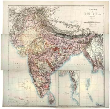
Railway map of India
Rare Books
Kirkpatrick Catalogue entry: "2493 [India. Survey of India Dept.] Railway map of India. [Calcutta, 1885]. 6 sheets. [see cabinet]." Submap: Continuation of the Province of Nritish Rurmah (Tenasserim Division) MS notes: Burton (map cabinet) India Railway . Prime meridian: GM. Relief: hachures. Graphic Scale: Miles. Projection: Polyconic. Printing Process: Lithography. Other Features: Sub-maps.
623667

Contour map of India
Rare Books
Kirkpatrick Catalogue entry: "2492 [India. Survey of India Dept.] Contour map of India. [Calcutta, 1886] 6 sheets. [see cabinet].""Based on a system of approximate contours." Two tables: "Table showing the Mean Elevation of India in different Latitudes" and "Table showing Lengths and Heights of Sources of the larger Rivers of India and the Areas drained by them." MS notes: Burton (map collection) India contour. Prime meridian: GM. Relief: contour lines. Graphic Scale: Miles. Projection: Polyconic. Printing Process: Lithography.
623666

The Goa's map genal transcribed and casticationed
Rare Books
Kirkpatrick Catalogue entry: "2487 l Goa. The Goas's map gen[er]al transcribed. [n.p., n.d.] 1 sheet (manuscript). [see cabinet]."Manuscript map. MS notes on symbols, not Burton's hand. There is one note that could be by Burton, just above the label for Anchumalu. Art work: Armillary sphere MS notes: Burton (map cabinet) Goa. 2487 Goa, East Coast, India. 12. Prime meridian: GM. Relief: no. Projection: Plane. Printing Process: Holographic. Other Features: Art Work.
623661
Image not available
Map of the Pamirs and adjacent territory
Rare Books
Kirkpatrick Catalogue entry: "2489 Great Britain. War Office. Intelligence Division. Map of the Pamirs and adjacent territory. London, Edward Stanford for the War Office, 1893. 1 sheet. [see cabinet]."Appeared in "Map of the country between Russian and Chinese Turkestan and British India. Compiled in the Intelligence Division, War Office, mainly from the Latest India Survey and Russian General Staff Maps under the Direction of Lt. Col. Y.C. Dalton."? MS notes: Burton (map cabinet) Great Britain War Office 2489.. Prime meridian: GM. Relief: hachures. Graphic Scale: Miles. Projection: Polyconic. Printing Process: Lithography.
623663

Gibraltar Bay : from the Spanish survey of 1872, the topography of Gibraltar from the Ordnance Survey of 1868
Rare Books
Kirkpatrick Catalogue entry: "2511 [Great Britain. Admiralty.] Gibraltar bay from the Spanish survey of 1872 . London, Admiralty, 1877. 1 sheet. At head of title: Strait of Gibraltar. [see cabinet]."At head of title: "Strait of Gibraltar." Several points marked with a red dot (lighthouses?). Two views of the coast, one at San Garcia Tower, one at Black Hill. Submap: Algeciras Roads. MS notes: Burton (map cabinet) Great Britain Admiralty Gibralter. Prime meridian: GM. Relief: hachures. Graphic Scale: Miles. Projection: Cylindrical. Printing Process: Lithography. Other Features: Sub-maps.
623685
Image not available
Carte Particuliere de Isthmus, ou Darien, Qui comprend le Golfe de Panama &ce. Cartegene, et les Isles Aux Environs
Visual Materials
Kashnor notes, "The Darien map shows New Edinburgh and the Golden Island, each flying the flag of the Scots West India Company." Submaps: Rade de Darien et les Isles aux Environs; Carte de la Rade de Cartagene et des Environs &c.. Prime meridian: Paris. Relief: pictorial. Graphic Scale: Leagues. Projection: Cylindrical. Watermark: P symbol. Printing Process: Copper engraving. Other Features: Sub-maps. Verso Text: MS note: 689.
093:689 M