Opening Hours
Daily: 10 A.M.–5 P.M.
Closed on Tuesdays
1151 Oxford Road
San Marino, CA 91108
Visual Materials
Daily: 10 A.M.–5 P.M.
Closed on Tuesdays
1151 Oxford Road
San Marino, CA 91108

Image not available
Visual Materials
The original map of 1734 was reduced in size by George Maurice Lowitz. Includes navigation routes for entering and leaving Manila and Magellan's route in 1521. Cartouche: Putti & Merman.. "Fol. I (upper right) MS note: 54 (upper left). Description of the history of the Philippine Islands lower left." "( Dediée a Sa Majesté Catholique, par le Brigadier Don Ferdinand Valdez Tamon, Chevalier de l'ordre de St. Jaques, Gouvenour & Captaine Genéral des dites Isles:) Dresée par le R. Pere Pierre Murillo Velarde, de la C. de Gieusu sur les Cartes, les Relations et les Navigations le plus exactus a Manille 1734. Par ordre de Sa Majesté. Tirée de l'Original, et réduite en cette forme par George Maurice Lowitz. Profess. en Mathem. a Nurenberg l'an 1750." Prime meridian: Ferro. Relief: pictorial. Graphic Scale: Leagues. Projection: Cylindrical. Watermark: Device. Printing Process: Copper engraving. Other Features: Cartouche. Verso Text: MS notes: 105/742.
105:742 M
Image not available
Visual Materials
Cartouche: Crowned floral. Vignettes: Vue des Terres entre le Cap d'Orange et Cayenne; Vue de la Coste aux Environs de Cayenne.. Prime meridian: Teneriffe, Ferro, Paris. Relief: pictorial. Graphic Scale: Leagues. Projection: Cylindrical. Watermark: Crowned two headed bird lettering. Printing Process: Copper engraving. Other Features: CartoucheVignettes. Verso Text: MS note: 657 Cotes de la Gayana..
093:658 M
Image not available
Rare Books
Kirkpatrick Catalogue entry: "2523 Monaco. Carte de la haute Italie littoral de la Méditerranée aux environs de Monaco, Menton, Sn. Rémo, Port Maurice, Savone, Voltri et Gênes. Cannes, F. Robaudy, 1880. 1 sheet. [see cabinet]."The map covers almost 200 kilometers of coastline, from Monaco to Genoa, though the portion of the map that shows Genoa has been lost. The majority of the land shown here lies in the modern Italian region of Liguria. The strip of land between Monaco and the Italian border, which includes Menton, is the French department of Alpes-Maritimes. Author's full name from French authority file. Relief: shaded. Graphic Scale: Miles, kilometers. Projection: Cylindrical. Printing Process: Lithography.
623696
Visual Materials
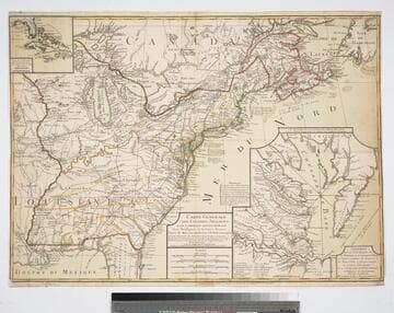
Proposed peace settlement lines shown. Submaps of Florida and Caribbean Islands, second submap of Chesapeake Bay area labeled: Suplément Qui represente la partie de la Virginie ou se trouvent le Theatre ou l'Armée Combinée des Francois et des Etats Unies a fait prisonnier le Geeneral Cornwalis Le 19 Octobre 1781 et le Plan d'attaque d'Yorck et de Glocester Par les Generaux Washington et Rochambeau. Le detail de la Baye de Chesapeake, par L. Denis... Many notes of battles fought during Revolutionary War. Submaps of Caribbean and Florida, Chesapeake Bay.. Prime meridian: Ferro. Relief: pictorial. Graphic Scale: Italian miles, Grand leagues, Common leagues, Journeys of Savages.. Projection: Pseudocylindrical. Watermark: Chain enclosed Maltese Cross. Printing Process: Copper engraving. Other Features: Sub-maps. References: McCorkle 783.18. Verso Text: MS note: 85.
093:085 M
Image not available
Visual Materials
Kashnor notes, "a rare French chart with the soundings." Contains submaps. Kashnor dates as ca. 1690. Submaps: Channel east of Isle de Orleans; l'Isle Rouge; Quebec to Lake Ontario extension; Havre St. Nicolas; Les Septe Isles. Vignette: view of traverse between Cape Tourmente and l'Isle de Orleans.. Prime meridian: Quebec. Relief: hachures. Projection: Mercator. Watermark: Beads with cross. Printing Process: Copper engraving. Other Features: VignettesSub-maps. Verso Text: MS note: 358.
093:358 M
Image not available
Visual Materials
Kashnor notes, "Shows the course of the Missouri extending north of the Rockies, where the Spaniards forded the river to trade with the people for yellow iron, "du fer jaune." Also shows Carolina, Virginia, Maryland, and New Mexico." This edition does not show New Orleans. Submap of the Mississippi delta. Appeared in information from RLIN record. See 105:478M for a later version and RB 52352 for a reproduction. Submap: Carte Particuliere des Embouchures de la Riviere S. Louis et de la Mobile. Prime meridian: Ferro. Relief: pictorial. Graphic Scale: Leagues. Projection: Cylindrical. Printing Process: Copper engraving. Verso Text: MS note: 550.
093:550 M