Rare Books
Plan of the Harbour of Carthagena

You might also be interested in
Image not available
Plan of the Bay and Island of Mobile
Rare Books
Map removed from "An account of the first discovery, and natural history of Florida", written by William Roberts, and published by Thomas Jefferys in 1763 (following page 8). Prime meridian: Gm. Relief: no. Graphic Scale: Leagues. Projection: Cylindrical. Printing Process: Copper engraving.
295806
Image not available
A Plan of the City and Environs of Philadelphia, with the Works and Encampments of His Majesty's Forces, under the Command of Lieutenant General Sir William Howe, K. B
Rare Books
Prime meridian: GM. Relief: hachures. Projection: Cylindrical. Watermark: Crowned shield GR WF. Printing Process: Copper engraving.
295808
Image not available
Plan of the District of Gaspe
Rare Books
"By Joseph Bouchette Surveyor General" "J. Walker Sculpt." Prime meridian: GM. Relief: hachures. Graphic Scale: Miles. Projection: Cylindrical. Printing Process: Copper engraving. Verso Text: MS notes; C45 31.
116682
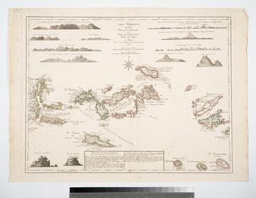
Les Vierges, Levées Par les Anglais, et Par les Dannois, Traduit de l'Anglais
Visual Materials
Description of the islands identifies Jefferys as cartographer. Views: (10) views of various islands. Table: Division des Isles Vierges... detailing ownership of the various islands, English, Danish, and Spanish claims.. Prime meridian: London, Ferro. Relief: hachures. Graphic Scale: Miles. Projection: Plane. Watermark: Chaqined maltese cross lettering. Printing Process: Copper engraving. Other Features: Art Work. Verso Text: MS note: 832.
105:832 M

A new map of the island of Cuba with correct plans of all the principal ports and harbours it contains
Rare Books
Removed from Universal Museum, November 1762, p 603. (Described in Cuba In Old Maps by Emilio Cueto, 1999.) Submaps: Ten Ports and harbors. Prime meridian: Ferro, London. Relief: pictorial. Graphic Scale: Leagues, miles. Projection: Cylindrical. Printing Process: Copper engraving.
295817

West India Islands And Adjacent Coasts of the United States, Mexico, Guatimala & Columbia
Visual Materials
Kashnor dates as ca. 1831. Submap: Island of Jamaica. "LXIV (upper left)" Prime meridian: GM. Relief: pictorial & hachures. Projection: Cylindrical. Printing Process: Copper engraving. Other Features: Sub-maps. Verso Text: MS notes: 974 West India Islands 64.
105:974 M