Rare Books
Plan of the Bay and Island of Mobile
You might also be interested in

A new map of the island of Cuba with correct plans of all the principal ports and harbours it contains
Rare Books
Removed from Universal Museum, November 1762, p 603. (Described in Cuba In Old Maps by Emilio Cueto, 1999.) Submaps: Ten Ports and harbors. Prime meridian: Ferro, London. Relief: pictorial. Graphic Scale: Leagues, miles. Projection: Cylindrical. Printing Process: Copper engraving.
295817

Plan of the Harbour of Carthagena
Rare Books
Appeared in Jefferys' A description of the Spanish islands and settlements..., 1762. MS notes: X65565 !2-1/2 x 8-3/4. Prime meridian: GM. Relief: hachures. Graphic Scale: Miles. Projection: Cylindrical. Printing Process: Copper engraving.
65565

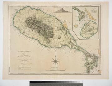
St. Christophers, or St. Kitts, surveyed By Anthony Ravell Esqr. Surveyor General of the Islands of St. Christophers, Nevis, & Montserrat. Engraved by Thomas Jefferys Geographer to the King
Visual Materials
See 093:827M for an earlier copy. Vignette: Nevis from shipboard Submap: Nevis, by Thomas Jefferys.. Prime meridian: London, Ferro. Relief: hachures. Graphic Scale: Miles, leagues. Projection: Cylindrical. Printing Process: Copper engraving. Other Features: VignettesSub-maps. Verso Text: MS notes: 828.
093:828 M

Island of Hispaniola called by the French St. Domingo. Subject to France & Spain. from the best Authorities by Thomas Jefferys, Geographer to His Majesty
Visual Materials
RLIN record shows Jefferys as "geographer to his Royal Highness the Prince of Wales." Prime meridian: London, Ferro. Relief: pictorial. Graphic Scale: Miles, leagues. Projection: Cylindrical. Watermark: Crowned fleur-di-lis JWhatman. Printing Process: Copper engraving. Verso Text: MS note: 418.
105:418 S
St. Christophers, or St. Kitts, surveyed By Anthony Ravell Esqr. Surveyor General of the Islands of St. Christophers, Nevis, & Montserrat. Engraved by Thomas Jefferys Geographer to the King
Visual Materials
See 093:828M for a later copy. Vignette: Nevis from shipboard Submap: Nevis, by Thomas Jefferys.. Prime meridian: London, Ferro. Relief: hachures. Graphic Scale: Miles, leagues. Projection: Cylindrical. Watermark: Crowned fluer-di-lid TW. Printing Process: Copper engraving. Other Features: VignettesSub-maps. Verso Text: MS notes: 827 43.
093:827 M
Image not available
Map of the most Inhabited part of New England containing the Provinces of Massachusets Bay and New Hampshire, with the Colonies of Conecticut and Rhode Island, Divided into Counties and Townships: The whole composed from Actual Surveys and its situation adjusted by Astronomical Observations
Visual Materials
Kashnor notes, "This is the old Colonial Map, originally engraved and issued by Thomas Jefferys, the plate having passed into the possession of the firm when the Jefferys and Sayer, and Sayer and Bennett firms became Laurie and Whittle." Two submaps. Patterned after Jeffreys' 1755 map, see McCorkle 755.19. Cartouche: Landing of the Mayflower at Plymouth. Submaps: Plan of the Town of Boston; Plan of Boston Harbor from an Accurate Survey.. Prime meridian: London. Relief: pictorial. Graphic Scale: Miles, leagues. Projection: Cylindrical. Printing Process: Copper engraving. Other Features: Sub-mapsCartouche. References: McCorkle 755.19.. Verso Text: MS notes: 457 England 4 Sheets (one sheet)..
093:457 M