Rare Books
A Plan of the City and Environs of Philadelphia, with the Works and Encampments of His Majesty's Forces, under the Command of Lieutenant General Sir William Howe, K. B
You might also be interested in
Image not available
Battle of Brandywine in which The Rebels were defeated, September the 11th 1777, by the Army under the Command of General Sr. Willm. Howe
Rare Books
S. W. Werner drew the plan of the Hessian forces. Prime meridian: GM. Relief: hachures. Graphic Scale: Yards. Projection: Cylindrical. Watermark: Crowned shield GR WF. Printing Process: Copper engraving.
295809

Plan of the City and Environs of Quebec, with its Siege and Blockade by the Americans : from the 8th of December 1775 to the 13th of May 1776 / Engraved by Wm. Faden
Rare Books
Prime meridian: GM. Relief: hachures. Graphic Scale: Yards. Projection: Plane. Watermark: WF; crowned shield. Printing Process: Copper engraving. Verso Text: MS note: 16.
291460
Image not available
An Exact Plan of Charles-town-Bar and Harbour : From an actual survey ; With the attack of Fort Sulivan, on the 28th of June 1776, By His Majesty's Squadron, Commanded by Sir Peter Parker
Rare Books
Prime meridian: GM. Relief: no. Graphic Scale: Miles. Projection: Cylindrical. Watermark: Crowned shield VI. Printing Process: Copper engraving.
295805
Image not available
Bay of Honduras, By Thos. Jefferys Geographer to His Majesty
Visual Materials
"BF 10. (upper right)" Prime meridian: London. Relief: pictorial. Projection: Cylindrical. Watermark: Crowned fleur-di-lis WF. Printing Process: Copper engraving. Verso Text: MS notes: 892 27.
105:892 M
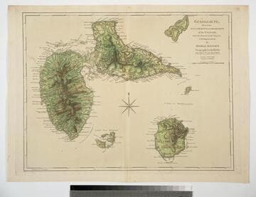
Guadaloupe, Done from Actual Surveys and Observations of the English, whilst the Island was in their possession with Improvements by Thomas Jefferys Geographer to the King
Visual Materials
See 093:772M for a later version of this map. Prime meridian: Ferro. Relief: hachures. Graphic Scale: Leagues. Projection: Cylindrical. Watermark: Crowned fleur-di-lis WF. Printing Process: Copper engraving. Verso Text: MS note: 771.
093:771
Image not available
A Plan of the City and Environs of Philadelphia
Rare Books
Includes an elevation of the new State House. Vignette: State House mat sticker 280. Prime meridian: GM. Relief: no. Graphic Scale: Miles. Projection: Cylindrical. Watermark: device: includes HK and cross. Printing Process: Copper engraving. Other Features: Vignettes. Verso Text: MS note: 150052.
150052