Visual Materials
Tabula novissima atque accuratissima Caraibicarum insularum sive Cannibalum : quae etiam Antillae Gallicae dicuntur, item insulae Supraventum, et in Archipelago Mexicano sitae sunt, ac detectae a Christ. Columbo Ao. [1493] nunc demum post varios aliorum conatus ex peritissimorum nautarum tabulis ac diariis, aliisque virorum solertium observationibus de natura ac fertilitate harum insularum, diligenter confecta, et in lucem edita / a Reinero Ottens Amstelaedamensi Geographo

You might also be interested in
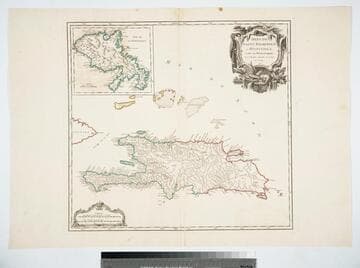
Isles de Saint Dominigue ou Hispaniola, et de la Martinique. Par le Sr. Robert, Geographe ord. du Roy, Avec Privilege. 1750
Visual Materials
Submap: Isle de la Martinique. Prime meridian: Ferro. Relief: pictorial. Graphic Scale: Leagues. Projection: Cylindrical. Watermark: Shield lettering. Printing Process: Copper engraving. Other Features: Sub-maps. Verso Text: MS note: 420 Stamped: St. Dominigue..
105:420 M

Indiae Orientalis : necnon insularum adiacentium ; nova descriptio edita / per F. de Witt Cum Privilegio Ordinum Hollandiae et Westfrisiae
Visual Materials
Kashnor notes, "Follows the Vischer map [105:747] in showing the Philippines and part of New Guinea with New Holland." Kashnor dates as ca. 1688. Cartouche: Chinese & Dutch traders, native woman. Prime meridian: Ferro. Relief: pictorial. Graphic Scale: Miles. Projection: Cylindrical. Printing Process: Copper engraving. Verso Text: MS note: 746.
105:746 M
Image not available
Amérique Septentrionale dresée sur les Relations les plus modernes des Voyageurs et Navigateurs, et divise suivant les différentes possessions des Européens
Visual Materials
Kashnor notes, "The inset map of the North-West is very interesting, showing Lac Bernarda, Lac de Fonte, and Det. d'Anian, and locates New Albion, P. de Drake, Pt. de Monterey, &c." This submap is the same map Didier Robert de Vaugondy published in the Supplement to Diderot's Encyclopedia in the same year. RLIN record identifies mapmaker as Gilles (father) rather than Didier (son). Submap of North-West showing de Fonte speculations.. Prime meridian: Ferro. Relief: pictorial. Graphic Scale: miles, leagues. Projection: Pseudocylindrical. Watermark: Shield lettering. Printing Process: Copper engraving. Other Features: CartoucheSub-maps. References: Phillips 3524. Verso Text: MS notes: 208 102.
105:208 M

L'Amérique Septentrionale et Meridionale divisée en ses principales parties par les Srs. Sanson Géog. ordin. du Roy rectifiée suivant les nouvelles découvertes et assigettie aux observations astronomiques, par le Sr. Robert Geog. ord. du Roi. Avec Privilege 1749
Visual Materials
Kashnor notes, "In this the coast of California only extends as far as Cape Blanc, and New Albion, Monterey and Cape Mendocin are located." See 093:158 for a later version of this map. Two submaps. Note map on verso. Kashnor states published in Paris. Two submaps; Isle de la Martinique; Isle de S. Domingue. Also table listing the various subdivisions of the continents.. Prime meridian: Ferro. Relief: pictorial. Graphic Scale: Miles, leagues. Projection: Pseudocylindrical. Printing Process: Copper engraving. Other Features: Sub-mapsCartouche. Verso Text: MS notes: Havana map 164a. (pasted to verso).
093:164 M
Image not available
Carte de la Virginie et du Maryland Dresée sur le grande carte Anglois de Mrs. Josué Fry et Pierre Jefferson, Par le Sr. Robert de Vaugondy Géographe ordinaire du Roi. Avec Privilege 1755
Visual Materials
Kashnor notes, " Also takes in the Delaware counties and part of New Jersey." "Grave E. Haullard" Prime meridian: Ferro. Relief: pictorial. Graphic Scale: Leagues. Projection: Cylindrical. Watermark: Shiled lettering. Printing Process: Copper engraving. Verso Text: Stamp: 105 MS note: 105-513.
105:513 M
Image not available
Partie Occidentale de la Nouvelle France ou du Canada Par Mr. Bellin Ingeniere du Roy et de la Marine Pour Seruir a'lIntelligence des Affaires et de l'Etat present en Amerique, communiquée au Public par les Heritiers de Homan, en l'an 1755
Visual Materials
Kashnor notes, "A good map of the Illinois country, and the present-day Wisconsin and Michigan territory." Cartouche: vined. Prime meridian: Ferro. Relief: pictorial. Graphic Scale: Leagues. Projection: Cylindrical. Watermark: LK device. Printing Process: Copper engraving. Other Features: Cartouche. Verso Text: MS note: 601.
093:601 M