Opening Hours
Daily: 10 A.M.–5 P.M.
Closed on Tuesdays
1151 Oxford Road
San Marino, CA 91108
Visual Materials
Daily: 10 A.M.–5 P.M.
Closed on Tuesdays
1151 Oxford Road
San Marino, CA 91108

Image not available
Visual Materials
Trimmed from upper right - Suppl. 7e. Carte. Atlas and publisher from McLaughlin and others. Submap titled Carte dresée sur la lettre de l'Amiral de Fonte par l"Ecrivain de la Californie.. Prime meridian: Paris. Relief: pictorial. Graphic Scale: No. Projection: Pseudocylindrical. Printing Process: Copper engraving. Other Features: Sub-maps.
105:012 S
Image not available
Rare Books
In upper right corner: 22. This map is another copy of map 93:537 and 105:646 from the Museum Bookstore Collection. Cartouche: floral Submap: Supplement pour la Caroline. Prime meridian: Paris. Relief: pictorial. Projection: Cylindrical. Watermark: Circular device- lettering. Printing Process: Copper engraving. Verso Text: Cours de l'Ohio MS notes: Maps - U.S. Robert de Vaugondy, Gilles Paris 1755 44193 835 30 319. Reference: McCorkle, map 755.37; McCorkle, map 295.
44193
Visual Materials
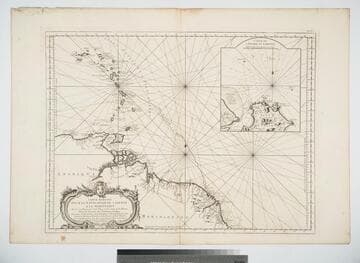
Inset map of Cayenne Harbor, French Guiana. Cartouche: shell and flowers. Submap: Carte de l'Entrée de Cayenne.. Prime meridian: Paris. Relief: pictorial. Graphic Scale: Leagues. Projection: Mercator. Watermark: Leaf-heart device lettering. Printing Process: Copper engraving. Other Features: CartoucheSub-maps. Verso Text: MS note: 472 .
105:472 M
Image not available
Visual Materials
Kashnor notes, "Though bearing a French title and imprint, with all names of places in French, it is obviously an English map issued to show the French claims and the English boundaries as well as French encroachments." McCorkle confirms map as by Kitchin, first edition. See also 093:515M for another copy. Kashnor implies the map is by Jean Palarait, but McCorkle explains that map to be a later copy of the Kitchin map. "Ou trouvera dans le troisiéme volume de la Nouvelle Introduction à la Géographie Moderne, que l'Auteur de l'Atlas Méthodique vient de mettre au jour, la description des pais, des pueples & des colonies de ce continent." Cartouche: flowered.. Prime meridian: London, Ferro. Relief: pictorial. Graphic Scale: Miles, leagues. Projection: Pseudocylindrical. Watermark: Crowned fleur-di-lis IV. Printing Process: Copper engraving. Other Features: Cartouche. References: McCorkle 755.22. Verso Text: Ms note: 622.
105:622 M
Image not available
Visual Materials
Kashnor notes, "Shows the course of the Missouri extending north of the Rockies, where the Spaniards forded the river to trade with the people for yellow iron, "du fer jaune." Also shows Carolina, Virginia, Maryland, and New Mexico." Kashnor dates as ca. 1720. This edition shows New Orleans. Submap of the Mississippi delta. MS note: 41 (upper right). Appeared in information from RLIN record. See 093:550M for an earlier version, 150047 for the same version, and 52352 for a reproduction. Submap: Carte Particuliere des Embouchures de la Riviere S. Louis et de la Mobile. Prime meridian: Ferro. Relief: pictorial. Graphic Scale: Leagues. Projection: Cylindrical. Printing Process: Copper engraving. Verso Text: MS note: 478.
105:478 M
Image not available
Visual Materials
Kashnor notes, "The map of Hudson's Bay is taken from Henry Elis, who made the voyage in 1746-47. There are three other charts of the Bay, Sanson, and Delisle, 1700 and 1703." This is one of the set of ten maps done by Didier Robert de Vaugondy for the Diderot Encyclopedia Supplement. It compares four views of Hudson's Bay to show the variance with time and information. See 105:433 for the DeLisle 1703 map. Kashnor refers to the lower right or latest map from Henry Ellis. Supple. Number trimmed from upper right margin. Four maps on one sheet. MS note: 436 (on backing).. Projection: Pseudocylindrical. Printing Process: Copper engraving.
105:436 S