Opening Hours
Daily: 10 A.M.–5 P.M.
Closed on Tuesdays
1151 Oxford Road
San Marino, CA 91108
Rare Books
Daily: 10 A.M.–5 P.M.
Closed on Tuesdays
1151 Oxford Road
San Marino, CA 91108

Image not available
Rare Books
Probably from a later edition of the Robert de Vaugondy atlas, based on Cumming's entry. Submap: Supplement pour la Caroline. Prime meridian: Ferro. Relief: pictorial. Graphic Scale: Leagues, Miles. Projection: Pseudocylindrical. Printing Process: Copper engraving. Verso Text: MS note: Vaugondy ... Reference: McCorkle, map 755.37; Cumming, map 295.
194247
Image not available
Visual Materials
Kashnor notes, " A good map of the Western country to the Mississippi at the junction with the Illinois River. Locates Canahogue, near the position of present-day Cleveland ; this implies there was a village therabouts in those days. This is the only map of the period which shows this." Inset map of Carolina coast. MS note: 99 (upper right). Possible duplicate 105:646. McCorkle provides appeared in info. Submap: Supplément pour la Caroline. Cartouche: flowered. MS 99 (upper right).. Prime meridian: Ferro. Relief: pictorial. Graphic Scale: Leagues, miles. Projection: Cylindrical. Watermark: Letytering device. Printing Process: Copper engraving. Other Features: Sub-mapsCartouche. References: McCorkle 755.37. Verso Text: MS notes: Vaugondy 1755 Partie de L. O. N. Cours de l. Ohio et Etas Unis. 99 Stamp: Coursdel'Ohio..
093:537 M
Image not available
Visual Materials
Kashnor notes, " The inset map shows all that was known of the country west of Lakes Superior and Michigan. The country now Minnesota and Wisconsin was known as far as Lake of the Woods, Chicago is located, and the present City of Cleveland was known as the Bay of Canahogue." Cartouche: boat with beaver. Submap: Supplement pour les Lacs du Canada. . Prime meridian: Ferro. Relief: pictorial. Graphic Scale: Leagues, miles. Projection: Cylindrical. Watermark: Lettering device. Printing Process: Copper engraving. Other Features: CartoucheSub-maps. References: McCorkle 755.36. Verso Text: MS notes: 538 588/50 Stamp: CAN ADA (split).
093:538 M
Image not available
Rare Books
Map shows 88 departments, but the National Assembly eventually settled on 83 departments. Large detailed map. Engraved by Charles Nicolas Varin. Inset: Département de Corse. Prime meridian: Paris. Relief: pictorial. Graphic Scale: Leagues. Projection: Polyconic. Printing Process: Copper engraving. Verso Text: MS note: 291070.
291070
Visual Materials
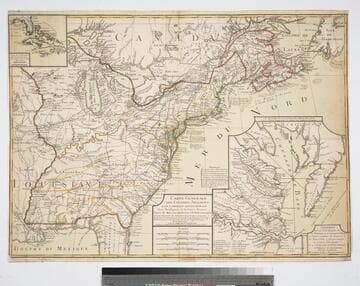
Proposed peace settlement lines shown. Submaps of Florida and Caribbean Islands, second submap of Chesapeake Bay area labeled: Suplément Qui represente la partie de la Virginie ou se trouvent le Theatre ou l'Armée Combinée des Francois et des Etats Unies a fait prisonnier le Geeneral Cornwalis Le 19 Octobre 1781 et le Plan d'attaque d'Yorck et de Glocester Par les Generaux Washington et Rochambeau. Le detail de la Baye de Chesapeake, par L. Denis... Many notes of battles fought during Revolutionary War. Submaps of Caribbean and Florida, Chesapeake Bay.. Prime meridian: Ferro. Relief: pictorial. Graphic Scale: Italian miles, Grand leagues, Common leagues, Journeys of Savages.. Projection: Pseudocylindrical. Watermark: Chain enclosed Maltese Cross. Printing Process: Copper engraving. Other Features: Sub-maps. References: McCorkle 783.18. Verso Text: MS note: 85.
093:085 M
Image not available
Visual Materials
Kashnor identifies Paris as production place. Submap of Boston Harbor. Submap: Plan du Havre de Baston.. Prime meridian: Paris, London, Lizard, Teneriffe, Fer. Relief: pictorial & hachures. Graphic Scale: Leagues. Projection: Mercator. Watermark: Lettering. Printing Process: Copper engraving. Other Features: Sub-maps. Verso Text: MS note: 454.
093:454 M