Visual Materials
Partie Occidentale de la Nouvelle France ou du Canada Par Mr. Bellin Ingeniere du Roy et de la Marine Pour Seruir a'lIntelligence des Affaires et de l'Etat present en Amerique, communiquée au Public par les Heritiers de Homan, en l'an 1755
You might also be interested in
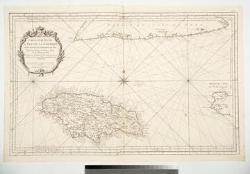
Carte Reduite de l'Isle de la Jamaique Pour servir aux Vaisseaux du Roy Dressée au Dépost des Cartes et Plans de la Marine en 1753
Visual Materials
Cartouche: framed w. flowers and Royal Crest.. Prime meridian: Ferro, Paris, Teneriffe. Relief: pictorial. Graphic Scale: Leagues. Projection: Cylindrical. Watermark: Device lettering. Printing Process: Copper engraving. Other Features: Cartouche. Verso Text: MS note: 790.
093:790 M
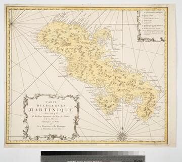
Carte de l'Isle de la Martinique dressée par Mr. Bellin, Ingenieur du Roy de France et de la Marine. communiquée au Public par les Heritiers de Homann a Nuremberg en l'an 1762
Visual Materials
Cartouche: framed.. Prime meridian: Paris. Relief: pictorial. Projection: Cylindrical. Watermark: Device. Printing Process: Copper engraving. Other Features: Cartouche. Verso Text: MS note: 815.
093:815 M
Image not available
Partie Occidentale de la Nouvelle France ou du Canada / par Mr. Bellin Ingenieur du Roy et de la Marine pour seruir a l'intelligence des affaries et de l'Etat present en Amerique
Rare Books
New France covers all the way to the Ohio River and Lac Long opening from Lake Superior leads to the apocryphal River of the West. Cartouche: vined. Prime meridian: Ferro. Relief: pictorial. Graphic Scale: Leagues. Projection: Pseudocylindrical. Watermark: Letters, symbol. Printing Process: Copper engraving. Verso Text: MS notes: 2268 2 pl. A-15.
442753
Image not available
Partie de l'Amerique Septent. qui comprend La Nouvelle France ou Le Canada, Par. le Sr. Robert de Vaugondy Geog. Ordinaire du Roy. Avec Privilege 1755
Visual Materials
Kashnor notes, " The inset map shows all that was known of the country west of Lakes Superior and Michigan. The country now Minnesota and Wisconsin was known as far as Lake of the Woods, Chicago is located, and the present City of Cleveland was known as the Bay of Canahogue." Cartouche: boat with beaver. Submap: Supplement pour les Lacs du Canada. . Prime meridian: Ferro. Relief: pictorial. Graphic Scale: Leagues, miles. Projection: Cylindrical. Watermark: Lettering device. Printing Process: Copper engraving. Other Features: CartoucheSub-maps. References: McCorkle 755.36. Verso Text: MS notes: 538 588/50 Stamp: CAN ADA (split).
093:538 M
Image not available
Les Lacs du Canada et Nouvelle Angleterre Par le Sr. Robert de Vaugondy, Fils de Mr. Robert Geog. ordin du Roi. Avec Privelege 1749
Visual Materials
Kashnor notes: "Shows the Illinois country to northern Mississippi, the present Wisconsin Territory." MS note: 403 (on backing). Prime meridian: Ferro. Relief: pictorial. Graphic Scale: Leagues. Projection: Pseudocylindrical. Watermark: Device. Printing Process: Copper engraving. Verso Text: MS note: 403 (on backing).
093:403 S
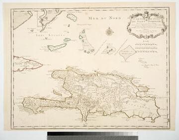
Carte de l'Isle de Saint Domingue Dresée en 1722 por le l'usage du Roy Sur les memoires de Mr. Frezier Ingenieur de. S. M. el autres assujetis aux Observations Astronomiques. Par G. Delisle premier Geographe du Roy, de l'Academie Rle. des Sciences. A Paris Chex l'Auteur sur le Quay de l'Horloge
Visual Materials
See 093:781M for a later copy. Cartouche: Framed w. coat of arms.. Prime meridian: Ferro. Relief: pictorial. Graphic Scale: Leagues. Projection: Cylindrical. Watermark: Chained Maltese cross device. Printing Process: Copper engraving. Other Features: Cartouche. Verso Text: MS note: 780.
093:780 M