Visual Materials
L'Amérique Septentrionale et Meridionale divisée en ses principales parties par les Srs. Sanson Géog. ordin. du Roy rectifiée suivant les nouvelles découvertes et assigettie aux observations astronomiques, par le Sr. Robert Geog. ord. du Roi. Avec Privilege 1749

You might also be interested in
Image not available
Amérique ou Indies Occidentales Par le Sr. Robert de Vaugondy Géog? Ord? du Roi, de feu Roi de Pologne Duc de Lorraine et de Bar et de l'Académie royale de Sciences at belles lettres de Nanci
Visual Materials
Kashnor notes, "A valuable map in being one of the last to give the old coast-line to the North-West from California to the supposed entrance to De Fonte's North-West Passage. The entrance to the River of the West is in practically the same latitude as the Columbia River, and the Entrance of Juan de Fuca is also correct. Cook was sailing up the coast when this was issued." Two submaps. Kashnor states published in Paris. See map 093:164 for an earlier version of this map. Two submaps; Isle de la Martinique; Isle de S. Domingue.. Prime meridian: Ferro. Relief: pictorial. Graphic Scale: Miles, leagues. Projection: Pseudocylindrical. Printing Process: Copper engraving. Other Features: Sub-maps. Verso Text: MS notes: 158 Amerique.
093:158 M
Image not available
Grande Riviere de Canada, appellée par les Europeans De St. Laurens
Visual Materials
Kashnor notes, "a rare French chart with the soundings." Contains submaps. Kashnor dates as ca. 1690. Submaps: Channel east of Isle de Orleans; l'Isle Rouge; Quebec to Lake Ontario extension; Havre St. Nicolas; Les Septe Isles. Vignette: view of traverse between Cape Tourmente and l'Isle de Orleans.. Prime meridian: Quebec. Relief: hachures. Projection: Mercator. Watermark: Beads with cross. Printing Process: Copper engraving. Other Features: VignettesSub-maps. Verso Text: MS note: 358.
093:358 M
Image not available
Amerique Septentrionale Par. N. Sanson Geographe Ordn. du Roy Revuë et changée en plusieurs endroits suivant les Memoires les plus recents augmentée et corrigée en cette seconde edition Par G. Sanson Geogr. Ordinaire du Roy
Visual Materials
Kashnor notes, "Shows California as an island, with the "Detroit de Anien" at its northern extremity. Locates Nouvelle Albion, Pt. de Francisco Draco, Monte Rey, and San Diego." McLaughlin identifies this map as state 2 of Sanson's 1669 map. Prime meridian: Ferro. Relief: pictorial. Projection: Pseudocylindrical. Watermark: Elaborate medallion lettering. Printing Process: Copper engraving. Other Features: Cartouche. References: McLaughlin 45; Wagner 399; Tooley 8 and 9; Leighly 53; BN Sanson V E (213). Verso Text: MS note: 209.
105:209 M
Image not available
L'Amerique Meridionale : Dressée sur les observations de Mrs. de l'Academie Royale des Sciences & quelques autres, & sur les memoires les plus recens / par N. Sanson
Visual Materials
This is Sanson's version of famous de l'Isle map with South America curving west. See 093:610 or RB 295821. Kashnor dates as ca. 1680, but de l'Isle's map preceded this one. Kashnor notes, "Shows the Argentine provinces as "Provinces de Rio de la Plata." Cartouche: Figures & scrolling. MS note: No. 1 (upper left). Prime meridian: Ferro. Relief: pictorial. Graphic Scale: Leagues. Projection: Pseudocylindrical. Printing Process: Copper engraving. Verso Text: MS notes: 631.
093:631 M
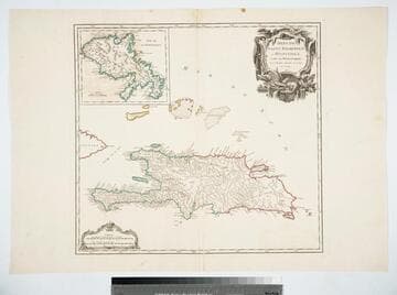
Isles de Saint Dominigue ou Hispaniola, et de la Martinique. Par le Sr. Robert, Geographe ord. du Roy, Avec Privilege. 1750
Visual Materials
Submap: Isle de la Martinique. Prime meridian: Ferro. Relief: pictorial. Graphic Scale: Leagues. Projection: Cylindrical. Watermark: Shield lettering. Printing Process: Copper engraving. Other Features: Sub-maps. Verso Text: MS note: 420 Stamped: St. Dominigue..
105:420 M
Image not available
Mappe-Monde Dresée a l'usage du Roy. Par Guillaume Delisle Premier Geographe de S. M
Visual Materials
Kashnor notes, "The western coast of America goes no further north than Cape Blanc, but California is a peninsula, although the gulf is very incorrectly represented. New Guinea appears as part of Australia. The route of Tasmon's voyage in 1642 is shown. This is one of Delisle's earlier maps, which show California as a peninsula." This is a copy of L'Isle's 1700 map (093:180) with added border art, redone cartouche, the tip of South America corrected, the Solomon Islands moved. Compare with 093:181M which Kashnor dated as [1720]. This map has a more correctly drawn California peninsula. Frisland is no longer shown below Greenland on this map. RLIN record gives appeared in information. Cartouche - figures representing four continents. Royal crest center. . Prime meridian: Ferro. Relief: pictorial. Projection: Dual Hemisphere. Printing Process: Copper engraving. Other Features: CartoucheSub-maps. References: Shirley 603 (mentioned). Verso Text: MS notes: 181.
105:244 M