Rare Books
A Map of South Carolina : Shewing the Settlements of the English, French, & Indian Nations from CharlesTown to the River Mississippi

You might also be interested in
Image not available
A map of the British and French settlements in North America
Visual Materials
Kashnor notes, "Locates all the French forts in the Ohio and Louisiana territories. A scarce map, issued as a supplement to a magazine during the Old French War." Variant of 105:662. RLIN record gives date and appeared in information. Shows separate North and South parts of South Carolina. Submap: Fort Frederick at Crown Point built by the French in 1731. [Lake Champlain]. MS note: 297 (on backing). Prime meridian: London. Relief: no. Projection: Mercator. Watermark: Crowned GR Lion rampant in seal. Printing Process: Copper engraving. Verso Text: MS note: 297 (on backing).
093:297 S
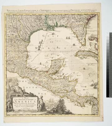
Map of the British Empire in America With the French, Spanish and the Dutch Settlements adjacent thereto by Henry Popple
Visual Materials
Kashnor notes, "Copied from Popple's map With the titles in English and French. ShoWs Carolina divided into counites, With Georgia and the Forts neWly erected, and Savannah." Kashnor dates as ca. 1740, RLIN record suggests 1755. Cartouche of Indians, traders. MS note: No. 10. Relief: pictorial. Projection: Cylindrical. Printing Process: Copper engraving. Other Features: Cartouche. References: McCorkle [741.2]. Verso Text: MS note: 326.
105:326 M
Image not available
South-Carolina and Parts Adjacent; Shewing the Movements of the American and British Armies
Visual Materials
Kashnor notes, " A rare and important map, indicating the encampments, marches, battles and skirmishes of the opposing armies, and giving a very clear and accurate view of the country. It was probably engraved by Abernethie of Charleston." Kashnor dates as ca. 1782. Prime meridian: London. Relief: hachures. Graphic Scale: Miles. Projection: Plane. Watermark: Shield TMW. Printing Process: Copper engraving. Verso Text: MS notes: 350 Mus. Col. #105.
105:350 M
Image not available
A New Map of Carolina
Visual Materials
Kashnor notes, "An important map, showing the exact state of the settlements in Carolina at the close of the XVII century. The inset map of Ashley River shows the names and locations of thirty-seven settlers." Kashnor dates as ca. 1680. Submap: A particular map for going into Ashley and Cooper Rivers. Table lists 33 settlers.. Prime meridian: London. Relief: pictorial. Graphic Scale: Miles. Projection: Cylindrical. Watermark: KO?. Printing Process: Copper engraving. Other Features: Sub-maps. Verso Text: MS notes: 96 105:336.
105:336 M

Sketch of the Environs of Charlestown in South Carolina
Visual Materials
Kashnor notes, " A rare plan, showing the Siege of Charleston, under command of Clinton and Admiral Arbuthnot, from 11 Feb. to 10 May, 1780, giving the movement of the troops from Edisto Inlet, the march to James Island, and the subsequent operations at Charlestown Neck." Kashnor dates as [1780]. Chronological description of movement of British Forces and emplacements of defenders. Keyed box lower right corner of map. . Relief: pictorial & hachures. Graphic Scale: Miles. Projection: Plane. Watermark: J B. Printing Process: Copper engraving.
093:084 M

Plan of the Attack on Fort Sulivan, the Key to Charlestown, in South Carolina, on the 28th of June 1776. By His Majesty's Squadron, Commanded by Sir Peter Parker. By an Officer on the Spot
Visual Materials
Kashnor notes, "A rare Carolina war map, showing the position of the fleet, the provincial troops, and the forces under Clinton." Letterpress description of the unsuccessful British attempt to take Fort Sulivan below map. See also 093:081M for another map of this battle. Attack description in a letter from Sir Peter Parker to Mr. Stephens, Secretary of the Admiralty dated July 9, 1776 with additional information on troop movements added from Whitehall, August 24. MS note: No. 80. Relief: hachures. Graphic Scale: miles. Projection: Plane. Watermark: Block W. Printing Process: Copper engraving. Verso Text: MS note: Mus. Cat. #93 #80..
093:080 M