Visual Materials
Sketch of the Environs of Charlestown in South Carolina

You might also be interested in

Plan of the Siege of Charlestown in South Carolina
Visual Materials
Kashnor notes, "This shows Charlestown Harbour from Fort Sullivan to Charlestown Neck, and locating the positions of the British Fleet with the boom across Cooper's River. On the neck is shown the encampment of the British Forces, and the three parallels which eventually led to the fall of the town." The siege of Charleston ended May 12, 1779 with surrender to British forces. MS note: 72 (on backing). Relief: pictorial & hachures. Graphic Scale: Miles, furlongs. Projection: Plane. Printing Process: Copper engraving. Verso Text: MS note: 72 (on backing).
093:072 S
Image not available
[Chart of the Coast of Georgia, South and North Carolina]
Visual Materials
Kashnor notes, "with inset charts of Charlestown Harbor, Cape Fear River and St. Mary's Inlet; also views of the entrance to Charlestown Harbour, seen North and South of Sullivan's Island, a scarce chart." Submaps: St. Mary's Inlet; Charleston; Cape Fear River. Vignettes: Appearance of the entrance to St. Mary's River from the bar; Appearance of Cape Roman, bearing N.b.W. distance 4 leagues; Charleston Churches, appearing Northward of Sulivans Island, there will be 5-1/2 fathoms on the Rattlesnake, but do not come any nearer than 5 fathoms; Charleston Churches, appearing Southward of Sulivan's Island clears the Rattlesnake.. Prime meridian: London. Relief: no. Projection: Mercator. Printing Process: Copper engraving. Other Features: VignettesSub-maps. Verso Text: Ms note: 363.
093:363 M

General Map of the Southern British Colonies in America. Comprehending North and South Carolina, Georgia, East and West Florida, with the Neighboring Indian Countries. From the Modern Surveys of Engineer de Brahm, Capt. Collet, Mouzon & Others and from the Large Hydrographical Survey of the Coasts of East and West Florida. By B. Romans, 1776
Visual Materials
Kashnor notes, "A valuable map, showing the main roads, issued during the early part of the American Revolution." Framed cartouche, submaps of Charlestown (sic) and St. Augustine.. Prime meridian: London. Relief: pictorial. Graphic Scale: Miles, leagues. Projection: Pseudocylindrical. Watermark: Crowned fleur-di-lis. Printing Process: Copper engraving. Other Features: Sub-mapsCartouche. Verso Text: MS note: 70.
093:070 M
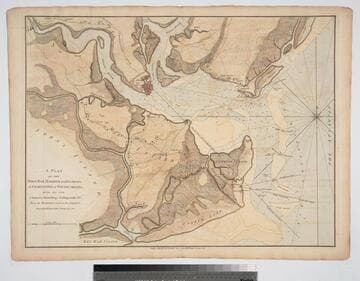
Plan of the Town, Bar, Harbour and Environs, of Charlestown in South Carolina, with all the Channels, Soundings, Sailing-marks &c. From the Surveys made in the Colony Engraved by William Faden, Charing Cross, 1780
Visual Materials
Kashnor notes, "A very scarce plan issued for use during the American Revolution." Atlas reference from The American Revolution 1775-1783, Naval History Division, Department of the Navy, Washington, 1972. Huntington f G1202 S3U5. Compass Rose. Relief: hachures. Graphic Scale: Miles. Projection: Cylindrical. Watermark: Crowned fleur-di-lis. Printing Process: Copper engraving.
093:082 M
![Seat of the War, in New England, by an American Volunteer [Submap]: Plan of the Town of Boston with the Attack on Bunkers-Hill in the Peninsula of Charlestown, the 17th. of June 1775. With the Marches of the Several Corps Sent by the Colonies. Towards Boston. with the Attack on Bunkers = Hill](/_next/image?url=https%3A%2F%2Frail.huntington.org%2FIIIF3%2FImage%2F22APN4KOYJI7%2Ffull%2F%5E360%2C%2F0%2Fdefault.jpg&w=750&q=75)
Seat of the War, in New England, by an American Volunteer [Submap]: Plan of the Town of Boston with the Attack on Bunkers-Hill in the Peninsula of Charlestown, the 17th. of June 1775. With the Marches of the Several Corps Sent by the Colonies. Towards Boston. with the Attack on Bunkers = Hill
Visual Materials
Kashnor notes, "A very fine and rare war plan, with both imprints. The Bunker's Hill plan shows Charlestown in flames." Two submaps: Plan of Boston Harbour from an Actual Survey. Plan of the Town of Boston.... Prime meridian: London. Relief: hachures. Graphic Scale: Miles, English. Projection: Cylindrical. Watermark: Crowned fluer-di-lis (half). Printing Process: Copper engraving. Other Features: Sub-maps. References: McCorkle 775.1. Verso Text: MS note: 128.
093:128 M
Image not available
Map of the most Inhabited part of Virginia, containing the whole Province of Maryland, with Part of Pensilvania, New Jersey and North Carolina, Drawn by Joshua Fry and Peter Jefferson in 1775
Visual Materials
Kashnor dates printing as [1776]. Cartouche: Traders shipping tobacco. Table: Road distances from Williamburg and other Virginia points as recorded by J. Dalrymple in 1755.. Prime meridian: Philadelphia, Curratuck Inlet. Relief: pictorial. Graphic Scale: Miles. Projection: Cylindrical. Watermark: Crowned fleur-di-lis over GR. Printing Process: Copper engraving. Other Features: Cartouche. Verso Text: MS notes: 589 25 26.
093:589 M