Visual Materials
South-Carolina and Parts Adjacent; Shewing the Movements of the American and British Armies
You might also be interested in

Sketch of the Operations before Charleston the Capital of South Carolina 1780
Visual Materials
Kashnor notes, "Shows the British warships bombarding the fort, and gives particulars of the forts, batteries, &c. of the opposing armies. 'Having surrendered by Capitulation the 12th May the Garrison laid down their Arms at I betwenn the Abbatis in front of the Hornwork.' Probably the earliest example of map engraving executed in South Carolina." [Ships shown are American and French, per "Dictionary of American Naval Fighting Ships."] This map State II per Wheat & Brun who identify published information, date. LC record shows Thomas Abernethie opened engraving & printing shop in Charleston, SC, ca. 1785. MS notes: 85 Mus. Col. #105 (on backing). Relief: hachures. Graphic Scale: Miles, statute. Projection: Plane. Watermark: Crowned shield. Printing Process: Copper engraving. References: Wheat and Brun 595. Verso Text: MS note: 85.
105:085 M
Image not available
Harbour of Casco Bay, and Islands Adjacent
Visual Materials
Kashnor notes, "Locates 'Casco Fort built by Col. Runamer', Fort George and the Irish New Settlemen, and Brunswick Town, near Kennebec River." Kashnor dates as ca. 1758 Relief: no. Graphic Scale: Miles. Projection: Plane. Printing Process: Copper engraving. Verso Text: MS note: 491.
105:491 M
Image not available
Map of the Eastern Townships of Lower Canada, Drawn principally from actual Survey for the British American Land Company, by A. Wells, Provincial Land Survr
Visual Materials
Kashnor notes, " Shows the enormous tracts of land held by the Company." [Each parcel hand colored.] Inset plan of Quebec City. Submap: Plan of Quebec [City]. Prime meridian: GM. Relief: hachures. Graphic Scale: Miles, leagues. Projection: Cylindrical. Printing Process: Engraving. Other Features: Sub-maps. Verso Text: MS notes: 2 sheets 350.
093:350 M

Island of Cuba with part of the Bahama Banks & the Martyrs. By Thos. Jeffereys, Geographer to his Majesty
Visual Materials
Kashnor notes, "Includes an accurate map of the adjacent seas, with soundings." Prime meridian: London, Ferro. Relief: pictorial. Projection: Mercator. Watermark: Crowned fleur-di-lis VI. Printing Process: Copper engraving. Verso Text: MS notes: 378 Island of Cuba & Bahama Banks.
105:378 M
Image not available
North America Divided into its III Principall Parts 1st English Part viz. English Empire containing the Articklands near Hudsons Bay, New North & South Wales, New Britain N. Foundland N Scotland N England N York N Jarsey Pennsylvania Maryland Virginia Carolina Carolina or Florida California Sommer Is Bahama Is Jamaica & the Carybys Is II Spanish Pt. viz N Spain pt of the Antilles III French Pt. viz N France & Pt of the Cariby Is
Visual Materials
Kashnor notes, "Shows California as an island. The country to the West of the Mississippi is marked "Tract of Land full of Wild Bulls." The position of the Missions, and location of the Indian Nations are indicated. A very fine and interesting map." Kashnor dates as ca. 1680. McLaughlin dates as [1690] and places London as site of publication. Map separately published. Map has corrected route of the Rio Grande (R. Escandado) but S. Fe still on wrong bank and the river is noted to flow underground through New Mexico. RLIN record suggests 1685 date. MS note: 1680. Folder contains reproduction.. Prime meridian: Ferro. Relief: pictorial. Projection: Mercator. Printing Process: Copper engraving. References: McLaughlin 107; Tooley 55 9Plate 49); Leighly 93.. Verso Text: MS notes: 273 Mus Bk 105-273.
105:273 M
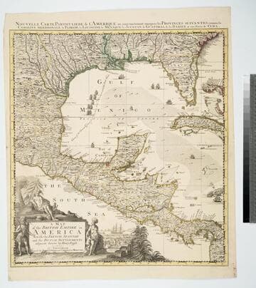
Map of the British Empire in America With the French, Spanish and the Dutch Settlements adjacent thereto by Henry Popple
Visual Materials
Kashnor notes, "Copied from Popple's map With the titles in English and French. ShoWs Carolina divided into counites, With Georgia and the Forts neWly erected, and Savannah." Kashnor dates as ca. 1740, RLIN record suggests 1755. Cartouche of Indians, traders. MS note: No. 10. Relief: pictorial. Projection: Cylindrical. Printing Process: Copper engraving. Other Features: Cartouche. References: McCorkle [741.2]. Verso Text: MS note: 326.
105:326 M