Rare Books
A Map of the Town of Providence From Actual Survey
You might also be interested in

Chart of the Saintes from an Actual Survey
Visual Materials
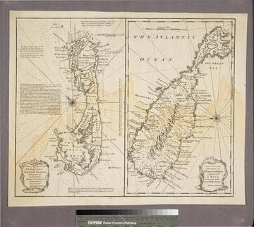
Some map mearsurements made by Charles Roberts, Master in the Royal Navy. MS note: 770. Relief: hachures. Graphic Scale: Miles. Projection: Plane. Printing Process: Copper engraving. Verso Text: MS note: 770.
093:770 M

Map of the Island of Tobago, Drawn from an Actual Survey. By. Thos. Bowen, 1779
Visual Materials
MS note: 835. Prime meridian: London. Relief: pictorial. Graphic Scale: Miles, leagues. Projection: Cylindrical. Printing Process: Copper engraving. Verso Text: MS note: 835.
093:835 S
New & Accurate Map of Bermudas or Sommer's Islands, taken from an Actual Survey wherein the Errors of former Charts are corrected. Accurate map of the Island of St. Christopher, vulgarly called St. Kits, Containg all the Towns, Villages, Forts &c
Visual Materials
Two maps on one sheet. Kashnor dates as ca. 1730. RLIN record dates as 1752. Prime meridian: London. Relief: pictorial. Projection: Plane. Printing Process: Copper engraving. Verso Text: MS note: 190.
105:190 S

Plan of the Isle of Trinidad, from actual Surveys made in the Year 1797
Visual Materials
Tables: The Island of Trinidad is Divided into the following Quarters; The Population of the I. of Trinidad 1797.. "Engraved by George Allen." Prime meridian: Port of Spain. Relief: hachures. Graphic Scale: Miles, leagues. Projection: Plane. Printing Process: Copper engraving.
105:807 M
Image not available
St. Ann's Bay and Harbour on the North East Side of Cape Breton Island. Surveyed by Thos. Backhouse. 1798
Visual Materials
Views of hills and farms.. "Engraved by J. Tuppen." Relief: hachures. Graphic Scale: Miles. Projection: Plane. Printing Process: Copper engraving. Other Features: VignettesCartouche. Verso Text: MS note: 599 13.
105:599 M

Plan of the Town of Basse Terre the Capital of Guadaloupe from an Authentic Survey
Visual Materials
Kashnor notes, "Issued shortly after the attack on Basse Terre during the Old French War." MS note: 778 (on backing). Relief: hachures. Graphic Scale: Yards. Projection: Plane. Watermark: P. Printing Process: Copper engraving. Verso Text: MS note: 778 (on backing).
093:778 S