Visual Materials
New & Accurate Map of Bermudas or Sommer's Islands, taken from an Actual Survey wherein the Errors of former Charts are corrected. Accurate map of the Island of St. Christopher, vulgarly called St. Kits, Containg all the Towns, Villages, Forts &c

You might also be interested in

New Map of the Island of St. Christophers being an Actual Survey taken by Mr. Andrew Norwood, Surveyr. Genll. ; New Map of the Island of Guardalupa. ; New Map of the Island of Martineca
Visual Materials
A later copy of Thornton's map. Three maps on one sheet. Kashnor dates as ca. 1730. Relief: pictorial. Graphic Scale: Miles. Projection: Plane. Printing Process: Copper engraving. Verso Text: MS notes: 780.
105:780
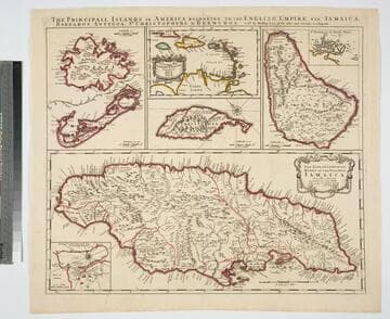
Principall Islands in America Belonging to the English Empire, viz Jamaica, Barbados, Antegoa, St. Christophers, & Bermudos
Visual Materials
Kashnor notes, "Contains one of the rarest maps of Bermuda." Kashnor dates as ca. 1685. Eight maps on one sheet. See 105:190 for later revised version. Eight maps on one sheet.. Relief: pictorial. Projection: Plane. Watermark: H. Printing Process: Copper engraving. Other Features: Sub-maps. Verso Text: MS note: 192.
105:192 M

New Map of the Island of St. Christophers being an Actual Survey taken by Mr. Andrew Norwood, Surveyr. Genll. By John Thornton at the Sign of England Scotland & Ireland in the Minories London. ; New Map of the Island of Guardalupa. ; New Map of the Island of Martineca
Visual Materials
Kashnor notes, "A rare first issue of Thornton's map. Locates the old plantations, and in many cases, with the owner's names." Three maps on one sheet. Kashnor dates as ca. 1680. Relief: pictorial. Graphic Scale: Miles. Projection: Plane. Printing Process: Copper engraving. Verso Text: MS notes: 778 Thornton St Christophers Il..
105:779

Dominia Anglorum in preacipius Insulis Americae, ut sunt Insula St. Christophi, Antegoa, Jamaica, Barbadoe, necnon Insulae Bermudes vel Sommers dictae
Visual Materials
Kashnor notes, "a scarce map. five maps on one sheet." Map title is both Latin and German, place names on maps in English. Kashnor dates as c. 1750, publication in Nuremberg. See 105:182M for another state of this map, possibly earlier. RLIN record dates as 1759. Five submaps: St. Kitts, Antigua, Bermuda, Barbados, Jamaica. Relief: pictorial. Graphic Scale: Milliaria. Projection: Plane. Watermark: Shield or device. Printing Process: Copper engraving. Verso Text: MS note: 950.
105:950 M

A new and accurate map of New Jersey, from the best authorities
Visual Materials
RLIN reference gives author, place of production, and notes this map is from Universal Magazine, v. 66, June 1780. Kashnor dates as circa 1780. MS note: 113 (on backing). Prime meridian: London. Relief: pictorial. Projection: Mercator. Watermark: Seal. Printing Process: Copper engraving.
105:113 S

A New and Accurate Map of Terra Firma and the Caribbe Islands
Visual Materials
Kashnor dates [circa 1714]. RLIN record suggests publication date as 1747. Cartouche: leaves.. "Drawn from the most approved Modern Maps & Charts, & adjusted by Astron. Observatns. By Eman. Bowen." Prime meridian: London. Relief: pictorial. Graphic Scale: Miles. Projection: Conic. Printing Process: Copper engraving. Other Features: Cartouche. Verso Text: MS note: 959.
105:959 M