Visual Materials
New Map of the Island of St. Christophers being an Actual Survey taken by Mr. Andrew Norwood, Surveyr. Genll. ; New Map of the Island of Guardalupa. ; New Map of the Island of Martineca

You might also be interested in

New Map of the Island of St. Christophers being an Actual Survey taken by Mr. Andrew Norwood, Surveyr. Genll. By John Thornton at the Sign of England Scotland & Ireland in the Minories London. ; New Map of the Island of Guardalupa. ; New Map of the Island of Martineca
Visual Materials
Kashnor notes, "A rare first issue of Thornton's map. Locates the old plantations, and in many cases, with the owner's names." Three maps on one sheet. Kashnor dates as ca. 1680. Relief: pictorial. Graphic Scale: Miles. Projection: Plane. Printing Process: Copper engraving. Verso Text: MS notes: 778 Thornton St Christophers Il..
105:779
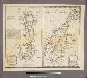
New & Accurate Map of Bermudas or Sommer's Islands, taken from an Actual Survey wherein the Errors of former Charts are corrected. Accurate map of the Island of St. Christopher, vulgarly called St. Kits, Containg all the Towns, Villages, Forts &c
Visual Materials
Two maps on one sheet. Kashnor dates as ca. 1730. RLIN record dates as 1752. Prime meridian: London. Relief: pictorial. Projection: Plane. Printing Process: Copper engraving. Verso Text: MS note: 190.
105:190 S

West India Islands - St. Christophers. ; West India Islands - Nevis. ; West India Islands - St. Lucia
Visual Materials
Three maps on one sheet. Kashnor dates as [1816]. Prime meridian: London, Ferro. Relief: hachures. Graphic Scale: Miles, leagues. Projection: Plane. Printing Process: Copper engraving. Verso Text: MS notes: 777 West Indies Thomson.
105:777

Island of St. Christophers, alias St. Kitts by H. Moll Geographer 1729
Visual Materials
MS note: 775 (on backing). Prime meridian: London. Relief: pictorial. Graphic Scale: Miles. Projection: Plane. Printing Process: Copper engraving.
105:775 S

A New and Accurate Map, of the Island of Martinico, 1763
Visual Materials
MS note: 508 (on backing). Prime meridian: London. Relief: pictorial. Graphic Scale: Miles. Projection: Plane. Printing Process: Copper engraving.
105:508 S

An Accurate Map of the Island of St. Christophers
Visual Materials
"from an Actual Survey; Shewing the Parishes,Churches and Rivers; Also the Bays, Rocks,. Shoals, and Soundings, that Surround the Whole." "Jno. Lodge Sculp. Political Mag. March 1782" MS note: 774 (on backing). Relief: pictorial. Graphic Scale: Miles. Projection: Plane. Watermark: Two seals GR. Printing Process: Copper engraving. References: Jolly Brit. Period. Pol-48;.
105:774 S