Visual Materials
Principall Islands in America Belonging to the English Empire, viz Jamaica, Barbados, Antegoa, St. Christophers, & Bermudos

You might also be interested in
Map of the English Empire in the Ocean of America or West Indies, revised by J. Senex; A New Map of the Island of Jamaica; Barbados & Bermuda; Tobago; Antego; St. Christophers; Harbour at Port Royall
Visual Materials
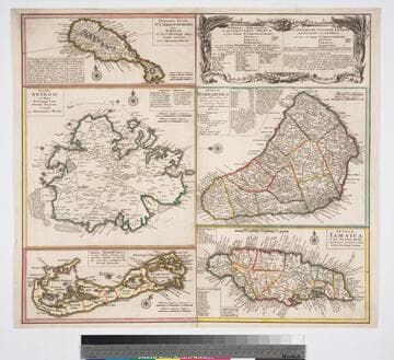
Kashnor notes," The map of Bermuda locates all the tribes." This map is eight maps on one sheet. See 105:192 for earlier version of this map. Eight maps on one sheet. MS notes: 10 Sen 0 Savanna, signifies a Plain . Relief: pictorial. Graphic Scale: varies. Projection: Plane. Printing Process: Copper engraving. Other Features: Sub-maps. Verso Text: MS note: 191.
105:191 M

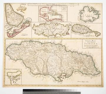
The Principall Islands in America belonging to the English Empire viz Jamaica, Barbados, Antegoa, St. Christophers, & Bermudos
Visual Materials
Five maps and two submaps on oner sheet. Kashnor dates as ca. 1690. Submaps: Jamaica; Antegoa; St. Christopher; Barbados; General map of the Cariby Islands; Port Royal; St. Michael or Bridg town. Prime meridian: London. Relief: pictorial. Projection: Plane. Printing Process: Copper engraving. Other Features: Sub-maps. Verso Text: MS note: 970.
105:970 M

Dominia Anglorum in preacipius Insulis Americae, ut sunt Insula St. Christophi, Antegoa, Jamaica, Barbadoe, necnon Insulae Bermudes vel Sommers dictae
Visual Materials
Kashnor notes, "a scarce map. five maps on one sheet." Map title is both Latin and German, place names on maps in English. Kashnor dates as c. 1750, publication in Nuremberg. See 105:182M for another state of this map, possibly earlier. RLIN record dates as 1759. Five submaps: St. Kitts, Antigua, Bermuda, Barbados, Jamaica. Relief: pictorial. Graphic Scale: Milliaria. Projection: Plane. Watermark: Shield or device. Printing Process: Copper engraving. Verso Text: MS note: 950.
105:950 M
Dominia anglorum in preacipuis insulis Americae : ut sunt insula St. Christophori Antego Jamaica Barbados nec non insulae Bermudos vel Sommer dictae singulari mappa omnia exhibita et edita / ab Homannianus Heredibus. Cum Privil. Sac. Caes. Majestatis
Visual Materials
Kashnor notes, "a scarce map. five maps on one sheet." Map title is both Latin and German, place names on maps in English. Kashnor dates as c. 1750, publication in Nuremberg. See 105:182M for another state of this map, possibly earlier. RLIN record dates as 1759. Other copies in OCLC dated as 1740. Also see 105:950M for another copy. Five submaps: St. Kitts, Antigua, Bermuda, Barbados, Jamaica. Relief: pictorial. Projection: Plane. Printing Process: Copper engraving.
093:132 M
Image not available
Dominia Anglorum in preacipuis insulis Americae : ut sunt Insula St. Christophi Antegoa Jamaica Barbados ; nec non Insulae Bermudes vel Sommers dictae, singulari mappa omnia exhibita et edita / Homannianis Heredibus ; cum Privil. Sac. Caes. Majestatis
Visual Materials
Kashnor notes, " Five maps on one sheet." Map title is both Latin and German, place names on maps in English. Kashnor dates as c. 1700, but according to Tooley Homann Erben did not begin to flourish until 1730. Prior to that, books from that press were ascribed to Johann Baptist Homann, who died in 1724. See 093:132M for another state of this map. Note changes in spelling of "Bermudes & Antegoa" versus "Bermudos & Antego" on 093:132M version of this map. Also, the "besandern" in alternate title is "aparten" on 093:132 version. Note Kashnor dated 093:132M as ca. 1750. Five submaps: St. Kitts, Antigua, Bermuda, Barbados, Jamaica. Relief: pictorial. Projection: Plane. Printing Process: Copper engraving. Verso Text: MS note: 182.
105:182 M
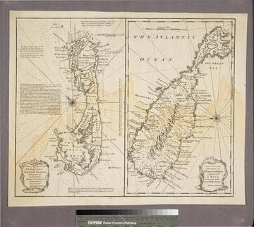
New & Accurate Map of Bermudas or Sommer's Islands, taken from an Actual Survey wherein the Errors of former Charts are corrected. Accurate map of the Island of St. Christopher, vulgarly called St. Kits, Containg all the Towns, Villages, Forts &c
Visual Materials
Two maps on one sheet. Kashnor dates as ca. 1730. RLIN record dates as 1752. Prime meridian: London. Relief: pictorial. Projection: Plane. Printing Process: Copper engraving. Verso Text: MS note: 190.
105:190 S