Visual Materials
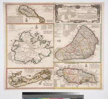
Dominia Anglorum in preacipuis insulis Americae : ut sunt Insula St. Christophi Antegoa Jamaica Barbados ; nec non Insulae Bermudes vel Sommers dictae, singulari mappa omnia exhibita et edita / Homannianis Heredibus ; cum Privil. Sac. Caes. Majestatis
You might also be interested in

Dominia Anglorum in preacipius Insulis Americae, ut sunt Insula St. Christophi, Antegoa, Jamaica, Barbadoe, necnon Insulae Bermudes vel Sommers dictae
Visual Materials
Kashnor notes, "a scarce map. five maps on one sheet." Map title is both Latin and German, place names on maps in English. Kashnor dates as c. 1750, publication in Nuremberg. See 105:182M for another state of this map, possibly earlier. RLIN record dates as 1759. Five submaps: St. Kitts, Antigua, Bermuda, Barbados, Jamaica. Relief: pictorial. Graphic Scale: Milliaria. Projection: Plane. Watermark: Shield or device. Printing Process: Copper engraving. Verso Text: MS note: 950.
105:950 M
Dominia anglorum in preacipuis insulis Americae : ut sunt insula St. Christophori Antego Jamaica Barbados nec non insulae Bermudos vel Sommer dictae singulari mappa omnia exhibita et edita / ab Homannianus Heredibus. Cum Privil. Sac. Caes. Majestatis
Visual Materials
Kashnor notes, "a scarce map. five maps on one sheet." Map title is both Latin and German, place names on maps in English. Kashnor dates as c. 1750, publication in Nuremberg. See 105:182M for another state of this map, possibly earlier. RLIN record dates as 1759. Other copies in OCLC dated as 1740. Also see 105:950M for another copy. Five submaps: St. Kitts, Antigua, Bermuda, Barbados, Jamaica. Relief: pictorial. Projection: Plane. Printing Process: Copper engraving.
093:132 M
Image not available
Fleuve Saint-Laurent, Représenté plus en détail que dans l'e'tendue de la Carte
Visual Materials
Kashnor notes, "Issued during the early part of the troubles regarding the encroachments, and supplementary to D'Anville's fine map on three sheets." Duplicate of 093:357M. Latitude and Longitude lines for Quebec marked. See 093:352 for an English version of this map which also attributes the data to D'Anville. Kashnor dates this map at [1755]. Kershaw notes as 1755. Relief: no. Graphic Scale: Leagues. Projection: Cylindrical. Watermark: Device - lettering. Printing Process: Copper engraving. References: Kershaw 625. Verso Text: MS note: 682 37.
105:682 M

Mappa geographica regionem Mexicanam et Floridam : terrasque adjacentes ut et anteriores Americae Insulas; cursus itidem et reditus navigantium versus flumen Missisipi et alias colonias ob oculos ponens ; cura et sumptibus / Matthaei Seutteri, S. Caes. et Reg. Cath. Maj. Geographi et Chalcographi
Rare Books
Note from 093:466 in Museum Book Store Collection: Kashnor notes, "Shows New Mexico, and locates Santa Fe, Taos, and other towns, also the Mississippi north to the Falls of St. Anthony." Lacks the four harbor submaps shown on 093:466. This map is a rework of L'Isle's 1703 map, see 093:464. Kashnor dates that one as ca. 1720. Seutter has erased Lotter's name from the title and substituted his own. RLIN record suggests 1756. Vignette: Battling ships watched from shore by traders. MS 50 (upper right). Prime meridian: Ferro. Relief: pictorial. Graphic Scale: Miles, leagues. Projection: Pseudocylindrical. Watermark: FAV. Printing Process: Copper engraving. Verso Text: MS note: Mexico et Florida. 150063 Sticker: 103 - Sales description pasted on.
150063
Image not available
A Plan of Port Royal in South Carolina Survey'd by Capn. John Gascoigne
Visual Materials
Kashnor notes, "A very rare war map of South Carolina. It shows the different islands, the chief plantations, the soundings of the harbour and rivers, and indicates places of military importance." [note from 093:380] [Hilton Head Island is named Trench's Island on this map.] See 093:380 for an earlier version of this map. The RLIN record covers an earlier version printed by Jefferys & Faden. Sailing directions.. Prime meridian: London. Relief: no. Graphic Scale: Miles. Projection: Plane. Printing Process: Copper engraving. Verso Text: MS note: 348.
105:348 M
Image not available
L'Amerique Meridionale : dressée sur les observations de Mrs. de l'Academie Royale des Sciences & quelques autres, & sur les memoires les plus recens / par G. de L'Isle
Visual Materials
Kashnor notes, "Shows the Argentine provinces as 'Provinces de Rio de la Plata'." [Shows l'Isle's 1700 version of this map with westward tilting South America.] See also 093:610M. Alt. title from upper margin. Cartouche: Natives. Prime meridian: Ferro. Relief: pictorial. Graphic Scale: Leagues. Projection: Pseudocylindrical. Printing Process: Copper engraving. Verso Text: MS note: 836.
105:836 M