Visual Materials
St. Christopher's

You might also be interested in

Island of Hispaniola called by the French St. Domingo. Subject to France & Spain. from the best Authorities by Thomas Jefferys, Geographer to His Majesty
Visual Materials
RLIN record shows Jefferys as "geographer to his Royal Highness the Prince of Wales." Prime meridian: London, Ferro. Relief: pictorial. Graphic Scale: Miles, leagues. Projection: Cylindrical. Watermark: Crowned fleur-di-lis JWhatman. Printing Process: Copper engraving. Verso Text: MS note: 418.
105:418 S

A New Map of Nova Scotia and Cape Britain. with the adjacent parts of New England and Canada, Composed from a great number of actual Surveys ; and other materials Regulated by many new Astronomical Observations of the Longitude as well as Latitude ; with an Explanation
Visual Materials
Kashnor notes, "The first issue of Jefferys' map. It was re-issued twenty years later by Sayer and Bennett." Kershaw states this is the second state of Jefferys map. Prime meridian: London, Ferro. Relief: pictorial. Graphic Scale: Miles, leagues. Projection: Pseudocylindrical. Watermark: I Ville Ary under IHS Crowned fleur-di-lis over LVC. Printing Process: Copper engraving. Other Features: Cartouche. References: Kershaw 739; McCorkle 755.20. Verso Text: MS note: 668.
105:668 M

Isle St. Christophe ou St. Kitts levé
Visual Materials
Jefferys died before this map was supposedly made. Submap: Isle Nevis par Jefferys. Vignette: View of Nevis from 6 or 7 leagues.. "Par. Ant:Ravell Chevalier Arpenteur Général des Isles de St. Chrostophe, Nevis et Montserrat." "Par Jefferys en 1775, Traduit de l'Anglais." Prime meridian: London. Relief: hachures. Graphic Scale: Miles, leagues. Projection: Plane. Watermark: Chained maltese cross lettering. Printing Process: Copper engraving. Other Features: VignettesSub-maps. Verso Text: MS note: 776.
105:776 M
Image not available
South America From the latest Discoveries, Shewing the Spanish & Portuguese Settlements according to Mr. D'Anville, by De Larochette
Visual Materials
Cartouche: ribboned w. coins & arrows.. Prime meridian: Ferro. Relief: pictorial. Graphic Scale: Miles, leagues, paces. Projection: Pseudocylindrical. Watermark: Crowned fleur-di-lis, IHS over Ivilledary. Printing Process: Copper engraving. Other Features: Cartouche. Verso Text: MS notes: 98 105/861.
105:861 M
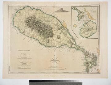
St. Christophers, or St. Kitts, surveyed By Anthony Ravell Esqr. Surveyor General of the Islands of St. Christophers, Nevis, & Montserrat. Engraved by Thomas Jefferys Geographer to the King
Visual Materials
See 093:828M for a later copy. Vignette: Nevis from shipboard Submap: Nevis, by Thomas Jefferys.. Prime meridian: London, Ferro. Relief: hachures. Graphic Scale: Miles, leagues. Projection: Cylindrical. Watermark: Crowned fluer-di-lid TW. Printing Process: Copper engraving. Other Features: VignettesSub-maps. Verso Text: MS notes: 827 43.
093:827 M
Image not available
Draught of Falklands Islands in the Latitude of 51° 22' South, Longitude 64° 30' West
Visual Materials
Vignettes: View of the Sebaldine latterly call'd Jasons Islands (9 views).. Prime meridian: London. Relief: no. Graphic Scale: Leagues. Projection: Plane. Watermark: Crowned fleur-di-lis IHS IVII L F DARY. Printing Process: Copper engraving. Other Features: Vignettes. Verso Text: MS notes: 656 62.
093:656 M