Visual Materials
Isle St. Christophe ou St. Kitts levé

You might also be interested in

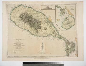
St. Christophers, or St. Kitts, surveyed By Anthony Ravell Esqr. Surveyor General of the Islands of St. Christophers, Nevis, & Montserrat. Engraved by Thomas Jefferys Geographer to the King
Visual Materials
See 093:827M for an earlier copy. Vignette: Nevis from shipboard Submap: Nevis, by Thomas Jefferys.. Prime meridian: London, Ferro. Relief: hachures. Graphic Scale: Miles, leagues. Projection: Cylindrical. Printing Process: Copper engraving. Other Features: VignettesSub-maps. Verso Text: MS notes: 828.
093:828 M
St. Christophers, or St. Kitts, surveyed By Anthony Ravell Esqr. Surveyor General of the Islands of St. Christophers, Nevis, & Montserrat. Engraved by Thomas Jefferys Geographer to the King
Visual Materials
See 093:828M for a later copy. Vignette: Nevis from shipboard Submap: Nevis, by Thomas Jefferys.. Prime meridian: London, Ferro. Relief: hachures. Graphic Scale: Miles, leagues. Projection: Cylindrical. Watermark: Crowned fluer-di-lid TW. Printing Process: Copper engraving. Other Features: VignettesSub-maps. Verso Text: MS notes: 827 43.
093:827 M

St. Christopher's
Visual Materials
Kashnor dates as [1768]. "Surveyed by Anthony Ravell Esqr. Surveyor General of the Islands of St. Christophers, Nevis, & Montserrat. Engraved by Thomas Jefferys Geographer to the King." Relief: hachures. Graphic Scale: Miles. Projection: Plane. Watermark: IHS I. Villadary Crowned fleur-di-lis. Printing Process: Copper engraving. Verso Text: MS note: 781.
105:781 M

Ruatan ou Rattan
Visual Materials
Includes two submaps. This island is located in the Gulf of Honduras. Submaps: Vielle Providence et Sta. Catalina [de Providencia Island]; Port de Nouveau Part Royal. Text in French describing the history of this island.. "levé Par Henry Barnsley Lieutenant Augmenté par Jefferys en 1775. Traduit de l'Anglais." Prime meridian: London. Relief: hachures. Graphic Scale: Leagues, miles. Projection: Plane. Watermark: Chained maltese cross lettering. Printing Process: Copper engraving. Other Features: Sub-maps. Verso Text: MS note: 773.
105:773 M
Image not available
Carte Hydrographique & Chorographique des Isles Phillippines
Visual Materials
The original map of 1734 was reduced in size by George Maurice Lowitz. Includes navigation routes for entering and leaving Manila and Magellan's route in 1521. Cartouche: Putti & Merman.. "Fol. I (upper right) MS note: 54 (upper left). Description of the history of the Philippine Islands lower left." "( Dediée a Sa Majesté Catholique, par le Brigadier Don Ferdinand Valdez Tamon, Chevalier de l'ordre de St. Jaques, Gouvenour & Captaine Genéral des dites Isles:) Dresée par le R. Pere Pierre Murillo Velarde, de la C. de Gieusu sur les Cartes, les Relations et les Navigations le plus exactus a Manille 1734. Par ordre de Sa Majesté. Tirée de l'Original, et réduite en cette forme par George Maurice Lowitz. Profess. en Mathem. a Nurenberg l'an 1750." Prime meridian: Ferro. Relief: pictorial. Graphic Scale: Leagues. Projection: Cylindrical. Watermark: Device. Printing Process: Copper engraving. Other Features: Cartouche. Verso Text: MS notes: 105/742.
105:742 M
Image not available
La Partie Meridionale de l'Amerique Appelée Terre Ferme ou se trouve Les Provinices ou Grands Gouvernemens de La Guiane et de La Nouvelle Grenade
Visual Materials
"cette derniere Province Subdivée en Popaya, Cartagene, Ste. Marthe, Rio de la Hacha, Venezuala, et Nouvelle Andalousie. Le Pays et Le Cours de la Riviere des Amazones Au Sud de cette Carte, Comme l'Istme de Panama au Nord-Ouest, si trouvent assé bien detaillez. Dresée Sur les Diverses Relations des Flibustiers et Fameux Voyageurs Par. N. de Fer. Geographe de sa Majesté Catolique 1719." Cartouche: vined. . Relief: pictorial. Graphic Scale: Leagues. Projection: Cylindrical. Watermark: Chained maltese cross lettering. Printing Process: Copper engraving. Other Features: Cartouche. Verso Text: MS note: 914.
105:914 M