Visual Materials
A Draught of Virginia from the Capes to York in York River and to Kuiquotan or Hainton in James River by Mark Tiddeman
You might also be interested in
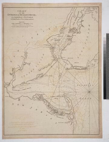
Chart of the Entrance of Hudson's River, from Sandy Hook to New York, with the Banks, Depths of Water, Sailing-marks &ca
Visual Materials
Kashnor notes, " The first issue of this chart. It was reissued in 1800 by Laurie & Whittle, but without date." Relief: hachures. Graphic Scale: Miles. Projection: Plane. Watermark: Crowned fleur-di-lis VI. Printing Process: Copper engraving. Verso Text: MS notes: 3 578.
105:578 M

Draught of New York from the Hook to New York Town by Mark Tiddeman
Visual Materials
Kashnor notes, "Locates New York, Blomindoll and Harlam on Manhattan, Brookland, Bushwyh, New Town, Flatbush, Bedford, Gravesend, Hendricks, Utrecht, Flushing and Whitestone on Long Island, and Schyler's Copper Mine, Newark and Elisabeth Town in New Jersey." Kashnor dates as [1758]. RLIN record suggest original print date as 1737, this map appearingt in the English Pilot from 1737-1773. A faint print. . Relief: hachures. Graphic Scale: Miles. Projection: Plane. Printing Process: Copper engraving. Verso Text: MS note: 497.
093:497 M

Plan of Cape Fear River from the Bar to Brunswick
Visual Materials
Kashnor notes, "A rare chart issued for use during the American Revolution." Shows Fort Johnston and harbor. Gives sailing directions for entering Cape Fear River. Prime meridian: London. Relief: pictorial. Graphic Scale: Leagues, miles. Projection: Cylindrical. Watermark: Crowned fleur-di-lis. Printing Process: Copper engraving. Verso Text: MS note: 78.
093:078 M
Image not available
A New and Correct Chart of the Coast of New Foundland, from Cape Raze to Cape Bonavista, with Chebucto Harbour in Nova Scotia done from the latest Observations
Visual Materials
Kashnor notes, "a fine chart, one of the earliest published charts of Newfoundland." Lightly printed. Kashnor dates as ca. 1752. Kershaw notes this plate was used till 1775 when "it was extremely worn and the impressions for several of the last editions are poor." Kershaw gives appeared in information. Submaps: Trinity Harbour; St. Johns Harbour; Chedabucto Harbour in Nova Scotia. Relief: no. Graphic Scale: Leagues, Miles. Projection: Plane. Printing Process: Copper engraving. Other Features: Sub-maps. References: Kershaw 523. Verso Text: MS note: 562.
105:562 M
Image not available
Virginia, Maryland, Pennsilvania, East & West New Jarsey
Visual Materials
Kashnor notes, "a valuable and rare chart." Kashnor dates as ca. 1685. RLIN record suggests date of 1689, gives appeared in information. Relief: no. Graphic Scale: Leagues. Projection: Cylindrical. Printing Process: Copper engraving. Other Features: Cartouche. Verso Text: MS note: 825.
105:825 M
Image not available
A Chart of the West Coast of Newfoundland, Surveyed by Order of Commodore Palliser, Governor of Newfoundland, Labrador, &c. &c. by James Cook, Surveyor
Visual Materials
Kashnor notes, "A scarce issue of Cook's famous chart." James Cook, later Captain James Cook, held the position of surveyor under Newfoundland's Governor Palliser between 1763 and 1767. See also 105:554M for another copy dated 1794. Submaps: Plan of Hawkes Harbour, Port Saunders and Keppel Harbour. Plan of York and Lark Harbours, in the Bay of Islands. Five views from ships anchored offshore.. Prime meridian: London. Relief: hachures. Graphic Scale: Leagues. Projection: Cylindrical. Printing Process: Copper engraving. Other Features: Sub-maps.
093:256 M