Visual Materials
Draught of New York from the Hook to New York Town by Mark Tiddeman

You might also be interested in
Image not available
New Map of New England. New York. New Jarsey. Pensilvania. Maryland. and Virginia
Visual Materials
Kashnor notes, "Shows the coast from Boston Harbor to the Chesapeake. The inset map locates New York, Bergen, West Chester and Flushing, Brookland, Newtown, Flatbush, Bedford, Utrecht and Gravesend on Long Island; in New Jersey it locates Newark, Woodbridge and Elizabeth Towne. Perth Citty, Dockura and Middletown." Kashnor dates ca. 1680. McCorkle confirms this is first edition, 1680. Submap: New York Harbor Cartouche with putti.. Relief: pictorial. Graphic Scale: Miles. Projection: Cylindrical. Printing Process: Copper engraving. Other Features: Sub-mapsCartouche. References: McCorkle 680.4. Verso Text: MS note: 93 489.
093:489 M

Chart of the Entrance to Hudson's River, from Sandy Hook to New York, with the Banks, Depths of Water, Sailing-marks, &ca
Visual Materials
Kashnor notes, "A scarce chart, issued during the early period of the American Revolution." Found in North-American pilot for New England, New York, Pensilvania (sic), Maryland, and Virginia 1777, per RLIN record. Relief: hachures. Graphic Scale: Miles, English. Projection: Plane. Watermark: Crowned fleur-di-lis. Printing Process: Copper engraving. References: Phillips 1209. Verso Text: MS note: 105.
093:105 M
Image not available
Particular Draught and Plans of some of the Principal Towns and Harbours belonging to the English, French, and Spaniards, in America and West Indies. Collected from the best Authorities. by Eman. Bowen
Visual Materials
Kashnor notes, "Boston Harbour, Placentia, Louisbourg, New York and Perth Amboy, Charles Town, Carolina, St. Augustine, Havana, Cartagena, Porto Bello, Etc." A total of thirteen maps on one sheet. MS note: 500 (on backing). Relief: pictorial. Graphic Scale: Miles. Projection: Plane. Printing Process: Copper engraving. Other Features: Sub-maps. Verso Text: MS note: 500 (on backing).
093:500 M
Image not available
A Draught of Virginia from the Capes to York in York River and to Kuiquotan or Hainton in James River by Mark Tiddeman
Visual Materials
Kashnor notes, "An unrecorded issue of this chart, probably the second issue by the Mounts, but before the Dublin issue of 1767." Kashnor dates as ca. 1758. Relief: no. Graphic Scale: Miles, leagues. Projection: Plane. Printing Process: Copper engraving. Verso Text: MS note: 815.
105:815 M
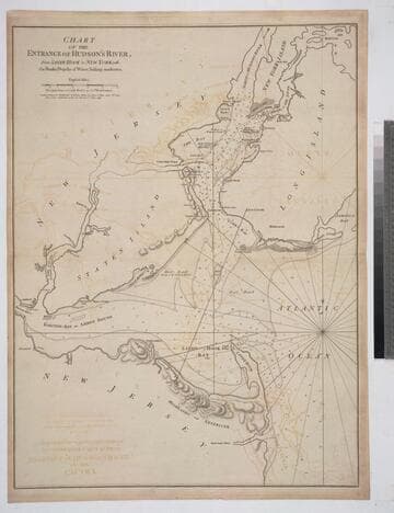
Chart of the Entrance of Hudson's River, from Sandy Hook to New York, with the Banks, Depths of Water, Sailing-marks &ca
Visual Materials
Kashnor notes, " The first issue of this chart. It was reissued in 1800 by Laurie & Whittle, but without date." Relief: hachures. Graphic Scale: Miles. Projection: Plane. Watermark: Crowned fleur-di-lis VI. Printing Process: Copper engraving. Verso Text: MS notes: 3 578.
105:578 M

Harbour of Charles Town in South Carolina from the Surveys of Sr. Jas. Wallace Captn in his Majesty's Navy & Others. with a View of the Town from the South Shore of Ashley River
Visual Materials
Kashnor notes, "One of the rarest views of Charles Town, in colours, it is very fine, and has the appearance of a water-colour drawing." View of city from south shore of Ashley River a fine water colored insert.. Relief: pictorial. Graphic Scale: Miles, statute & nautical. Projection: Plane. Printing Process: Copper engraving. Other Features: Art Work. Verso Text: MS note: 71.
093:071 M