Visual Materials
Plan of Ticonderoga
You might also be interested in
Image not available
Map of that part of America which was the Principal Seat of War. in 1756
Visual Materials
Kashnor notes, "Nova Scotia to Massachusetts, and westward to Lake Ontario and the St. Lawrence." Kashnor dates as ca. 1760. RLIN record suggests printing date of 1757. MS note: 661 (on backing). Prime meridian: London. Relief: pictorial. Graphic Scale: Miles, leagues. Projection: Pseudocylindrical. Printing Process: Copper engraving.
105:661 S
Image not available
North America
Visual Materials
Kashnor shows author as [N. Salmon, 1753] and notes engraved by J. Gibson. RLIN record suggests printing date as late as 1780. MS note: 342 (on backing). Prime meridian: London. Relief: pictorial. Projection: Pseudocylindrical. Watermark: VI. Printing Process: Copper engraving.
105:342 S
Image not available
New and Accurate Map of Virginia & Maryland Laid Down from Surveys and Regulated by Astron'l Observat'ns. By Eman. Bowen
Visual Materials
Kashnor dates as ca. 1750. RLIN record suggests 1792, gives appeared in information. Shadow of text transfer on map surface. MS note: 820 (on backing).. Prime meridian: London. Relief: no. Graphic Scale: Miles. Projection: Cylindrical. Printing Process: Copper engraving. Verso Text: Shadow of text transfer on verso..
105:820 S
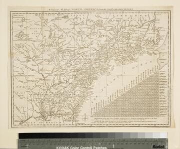
General Map of North America from the Latest Observations
Visual Materials
Kashnor gives date as [1776] RLIN record suggests 1778. Map includes distance chart between 29 American and Canadian cities. Bounds of Hudsons Bay [Co.] shown by Treaty of Utrecht. MS note: 102 (on backing). Prime meridian: London. Relief: pictorial. Projection: Mercator. Printing Process: Copper engraving. Verso Text: MS note: 1776.
105:102 S
Image not available
Carte de la Nouvelle Angleterre, Nouvelle York, Nouvelle Jersey, et Pensilvanie
Visual Materials
Kashnor dates as ca. 1720. This is a French copy of Moll's 1720 map. RLIN record suggests publication may have been as late as 1756. "Pl 20." (upper right). "2[?]" (lower right). MS note: 576 (on backing). Prime meridian: Ferro. Relief: pictorial. Graphic Scale: Leagues. Projection: Cylindrical. Printing Process: Copper engraving.
105:576 S
Image not available
A Map of the British and French Settlements in North America
Visual Materials
Kashnor notes, "shewing the French encroachment and forts, and with an account of the English claims to the territories in dispute." Kashnor dates as ca. 1756. RLIN record suggests 1750-59. Cartouche includes Lodge's name. Detailed history of various English colonies. MS note: 622 (on backing).. Prime meridian: London. Relief: pictorial. Projection: Mercator. Printing Process: Copper engraving. Other Features: Cartouche. Verso Text: MS notes: 63 G47.
105:662 S