Manuscripts
Plat of the Tracts of Land at the Mission of San Gabriel finally confirmed to J.S. Alemany, Bishop

You might also be interested in

Plat of the Ex Mission de San Fernando finally confirmed to Eulogio de Celis
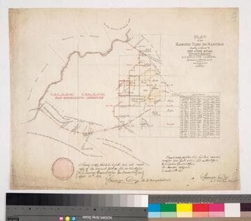
Manuscripts
Bordered by Ranchos El Encino, Tujunga, El Escorpion, Providencia, Las Virgines, . Showing San Fernando Farm Homestead Assn., Pico Reservation, Santa Susanna & San Fernando Mtns., . Colored by H. B. Lewis, 1897. ; Delineated by William P. Reynolds.. Tables: boundaries, connecting lines of the 8 tracts, exterior boundaries of the Ex mission, table A with acreage of the plaintiffs & defendants; map numbered #3062 on verso.
mssSolano SR_Map_0795
![Plat of the Rancho Los Cierritos [Cerritos] finally confirmed to Juan Temple](/_next/image?url=https%3A%2F%2Frail.huntington.org%2FIIIF3%2FImage%2F22APN4KPHI01%2Ffull%2F%5E360%2C%2F0%2Fdefault.jpg&w=750&q=75)
Plat of the Rancho Los Cierritos [Cerritos] finally confirmed to Juan Temple
Manuscripts
Bordered by Ranchos Los Alamitos, San Pedro, Los Coyotes, Santa Gertrudes; Pacific Ocean. Inset with extensive table of boundaries. Color highlights; hachures; San Gabriel River; Juan Temple's house indicated, 22194 35/100 acres. Var. 13° 30' E.
mssSolano SR_Map_0037
Plat of the Rancho Paso de Bartolo finally confirmed to Pio Pico et al
Manuscripts
Bordered by Ranchos Santa Gertrudes, San Antonio, La Merced, Potrero de Felipe Lugo, La Puente, San Gabriel River. Copy certified by Sherman Day, Surveyor General; Var. 15° 30' East. Inset with table of boundaries. T.2S. R.12W., T.2S. R.11W. S.B.M.
mssSolano SR_Map_0097

Map of the Rancho San Pascual finally confirmed to Manuel Garfias
Manuscripts
Bordered by Ranchos San Rafael, Santa Anita (not indicated on map). Subdivision and surface detail: Arroyo Seco, hachures, color highlights, trees; Griffin's and Wilson's ditches, body of water; Redmont area. Inset with table - boundaries, distances.
mssSolano SR_Map_0169

Plat of the Santa Anita Rancho finally confirmed to Henry Dalton
Manuscripts
Sierra Madre/San Gabriel mtns to the north. Insets with data tables for boundaries. Vertified by J. W Mandeville Sep. 18, 1858. Parcel owners indicated; minor color.
mssSolano SR_Map_0241

San Gabriel Mission burial ground
Visual Materials
Image of the San Gabriel Mission cemetery, with graves enclosed in picket fences and marked with wooden crosses in San Gabriel, California.
photCL 555