Manuscripts
Map of the Rancho San Pascual finally confirmed to Manuel Garfias

You might also be interested in
![Plat of the Rancho Los Cierritos [Cerritos] finally confirmed to Juan Temple](/_next/image?url=https%3A%2F%2Frail.huntington.org%2FIIIF3%2FImage%2F22APN4KPHI01%2Ffull%2F%5E360%2C%2F0%2Fdefault.jpg&w=750&q=75)
Plat of the Rancho Los Cierritos [Cerritos] finally confirmed to Juan Temple
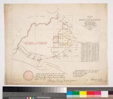
Manuscripts
Bordered by Ranchos Los Alamitos, San Pedro, Los Coyotes, Santa Gertrudes; Pacific Ocean. Inset with extensive table of boundaries. Color highlights; hachures; San Gabriel River; Juan Temple's house indicated, 22194 35/100 acres. Var. 13° 30' E.
mssSolano SR_Map_0037

Parcel map Township 1 South Range 12 West San Bernardino Meridian
Manuscripts
Bordered by parts of Ranchos San Pascual, San Rafael, Potrero Grande, San Antonio, La Merced. San Gabriel Mission lands: detailed parcel map: coordinates, acreage; hachures for land features, color highlights; inset with table - meanders of the Arroyo Seco. Copied by Alfred Solano. Title supplied by cataloger.
mssSolano SR_Map_0153.01

Plat of the Rancho Los Alamitos finally confirmed to A. Stearns
Manuscripts
Bordered by Los Cerritos Rancho, Pacific Ocean, Rancho Bolsa Chica, Ranchos Los Bolsas, Rancho Los Coyotes. Surveyed under the Instructions from the U.S. Surveyor General. Approved 1860 & 1861 by J.W. Mandeville (?) and L. Upson, 1867, U.S. Surveyor Generals Cal.. Colored highlights around boundaries. Includes two bays and numerous sloughs. Boundary landmarks. T. IV S.R. XII W, T IV S.R. XI W., T V S.R. XIII W., T.V S.R. XI W., T V S.R. XII W.. Inset with table of boundary coordinates and distances
mssSolano SR_Map_0006

Map of that part of the Rancho San Pedro allotted to Manuel Dominguez
Manuscripts
Bordered by Pacific Ocean, Rancho Los Cerritos, Sausal Redondo. Showing parcel owners: heirs of Maria Engracia Cota de Dominguez. Surface detail: hachures, water bodies, vegetation, subdivisions; color highlighting. Numerous tables with partitioned tract data, courses, distances, owners; table of allotments, Inner Bay, Salt Flat, Rattlesnake Island courses, distances. Signed by witnesses.
mssSolano SR_Map_0797

Plat of the Rancho Paso de Bartolo.; finally confirmed to Pio Pico and Juan Perez
Manuscripts
Bordered by Ranchos San Antonio, La Merced, La Puente, Santa Gertrudes; property of McFarland & Downey. Bound within document: "Field Notes and Map of the Rancho Paso de Bartolo..." (Hansen) Showing San Gabriel River, subdivided public lands, townships & section numbers, courses & distances, structures, surface details; with survey notes, table of boundaries, certification; colored inks. Alt. title supplied by cataloger.
mssSolano SR_Box_22(07).14
Plat of the Rancho Paso de Bartolo finally confirmed to Pio Pico et al
Manuscripts
Bordered by Ranchos Santa Gertrudes, San Antonio, La Merced, Potrero de Felipe Lugo, La Puente, San Gabriel River. Copy certified by Sherman Day, Surveyor General; Var. 15° 30' East. Inset with table of boundaries. T.2S. R.12W., T.2S. R.11W. S.B.M.
mssSolano SR_Map_0097