Manuscripts
Plat of the Rancho Los Cierritos [Cerritos] finally confirmed to Juan Temple

You might also be interested in
Plat of the Rancho Paso de Bartolo finally confirmed to Pio Pico et al
Manuscripts
Bordered by Ranchos Santa Gertrudes, San Antonio, La Merced, Potrero de Felipe Lugo, La Puente, San Gabriel River. Copy certified by Sherman Day, Surveyor General; Var. 15° 30' East. Inset with table of boundaries. T.2S. R.12W., T.2S. R.11W. S.B.M.
mssSolano SR_Map_0097

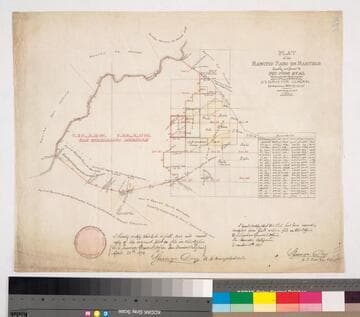
Plat of the Part of the Rancho Santa Gertrudes finally confirmed to James P. McFarland and John G. Downey
Manuscripts
Bordered by Ranchos San Antonio, Los Cerritos, Los Coyotes, La Habra and public lands. by decree of Aug. 13, 1869, with annotation of 1882 . . . containing 17,602.01 acres. Maps are numbered in upper left corner. #1 inset with table of boundary data; shows San Gabriel River, San Jose Creek, now New San Gabriel River; shows Rancho Paso de Bartolo confirmed to Pio Pico & Bernardino Guirado. #2 part of Gertrudes confirmed to Tomas Sanchez Colima; part of Paso de Bartolo. #3 parcels in black ink: 1 May 1882 S.G.L.A. to Dunlap & Tyler 500 acres.
mssSolano SR_Map_0251.01A

Plat of the Part of the Rancho Santa Gertrudes finally confirmed to James P. McFarland and John G. Downey
Manuscripts
Bordered by Ranchos San Antonio, Los Cerritos, Los Coyotes, La Habra and public lands. by decree of Aug. 13, 1869, with annotation of 1882... containing 17.602.01 acres. [Maps are numbered in upper left corner]. #1 inset with table of boundary data; shows San Gabriel River, San Jose Creek, now New San Gabriel River; show Rancho Paso de Bartolo confirmed to Pio Pico & Bernardino Guirado. #2 part of Gertrudes confirmed to Tomas Sanchez Colima; part of Paso de Bartolo. #3 parcels in black ink: 1 May 1882 S.G.L.A. to Dunlap & Tyler 500 acres
mssSolano SR_Map_0251.01B

Plat of the Part of the Rancho Santa Gertrudes finally confirmed to James P. McFarland and John G. Downey
Manuscripts
Bordered by Ranchos San Antonio, Los Cerritos, Los Coyotes, La Habra and public lands. by decree of Aug. 13, 1869, with annotation of 1882... containing 17.602.01 acres. [Maps are numbered in upper left corner]. #1 inset with table of boundary data; shows San Gabriel River, San Jose Creek, now New San Gabriel River; show Rancho Paso de Bartolo confirmed to Pio Pico & Bernardino Guirado. #2 part of Gertrudes confirmed to Tomas Sanchez Colima; part of Paso de Bartolo. #3 parcels in black ink: 1 May 1882 S.G.L.A. to Dunlap & Tyler 500 acres
mssSolano SR_Map_0251.01C

Plat of the Rancho Los Alamitos finally confirmed to A. Stearns
Manuscripts
Bordered by Los Cerritos Rancho, Pacific Ocean, Rancho Bolsa Chica, Ranchos Los Bolsas, Rancho Los Coyotes. Surveyed under the Instructions from the U.S. Surveyor General. Approved 1860 & 1861 by J.W. Mandeville (?) and L. Upson, 1867, U.S. Surveyor Generals Cal.. Colored highlights around boundaries. Includes two bays and numerous sloughs. Boundary landmarks. T. IV S.R. XII W, T IV S.R. XI W., T V S.R. XIII W., T.V S.R. XI W., T V S.R. XII W.. Inset with table of boundary coordinates and distances
mssSolano SR_Map_0006
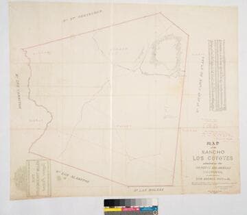
Map of the Rancho Los Coyotes
Manuscripts
Bordered by Ranchos San Juan Cajon de Santa Ana, Las Bolsas, Los Alamitos, Los Cerritos, Santa Gertrudes. Hachures & color highlights. Inset with table of coordinates. Confirmed to don Andres Pico, et al.. Var. 13° 30' E. Jan 22, 1861, divisions by Wm. H. Leighton
mssSolano SR_Map_0050