Manuscripts
Plat of the Ex Mission de San Fernando finally confirmed to Eulogio de Celis

You might also be interested in
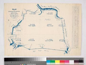
Plat of the ex Mission of San Fernando
Manuscripts
Bordered by Santa Susana Mtns., Sierra Madre or San Fernando Mtn., Tujunga Rancho, Rancho San Rafael, Providenicia y Cahuenga, High Rough Mtn., Rancho Las Virgenes. Finally confirmed to Eulogio de Celis . . . Var. 13° 30' East. Inset of table with courses & distances.
mssSolano SR_Map_0141

Plat of the Santa Anita Rancho finally confirmed to Henry Dalton
Manuscripts
Sierra Madre/San Gabriel mtns to the north. Insets with data tables for boundaries. Vertified by J. W Mandeville Sep. 18, 1858. Parcel owners indicated; minor color.
mssSolano SR_Map_0241

Plat of the Tracts of Land at the Mission of San Gabriel finally confirmed to J.S. Alemany, Bishop
Manuscripts
Inside folder marked, "Mission San Gabriel," with inset: Sketch showing the connection of surveys at San Gabriel Mission with public surveys; with table of boundaries, verification; showing township, tract & lot numbers, posts/stations. Alt. title supplied by cataloger.
mssSolano SR_Box_26(11).04

Plat of the Subdivision of the Rancho Azusa finally confirmed to Andreas Duarte
Manuscripts
Bordered by Azusa Mtns., Santa Anita Rancho, San Francisquito Rancho, Azusa Rancho de Henry Dalton, bed of the San Gabriel River. Color highlights; pencil annotation. Hachures (mountains). "Surveyed at the request of Eugene Meyer Es__"[?faded out]. Subdivisions are lettered and numbered. Roads indicated: Downey, Griffin, Zapate, Winston, Main, Santa Anita and River
mssSolano SR_Map_0010

Plat of the Rancho Los Felis finally confirmed to Maria Ygnacia Berdugo
Manuscripts
Ranchos San Rafael, Providencia, Pueblo lands of Los Angeles. Color highlights; var. 14°15' E. Pencil annotations: "Thos. E. Fraser," calculations. Berdugo = Verdugo. Alternate title supplied by cataloger.
mssSolano SR_Map_0064

Plat of the Santa Anita Rancho finally confirmed to Henry Dalton
Manuscripts
Sierra Madre or San Gabriel Mtns Color highlighting ; featuring parcel owners, township & section numbers, stations, courses, distances, acreage, with two tables of boundary data ; minor surface detail. Alt. title supplied by cataloger.
mssSolano SR_Box_25(06).01