Manuscripts
Plat of the Rancho Los Felis finally confirmed to Maria Ygnacia Berdugo

You might also be interested in

Plat of the Rancho Los Felis.; confirmed to Maria Ignacia Berdugo
Manuscripts
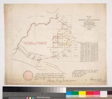
Bordered by Rancho Julio Berdugo (N), Los Angeles River (NE). Inset with table of stations, bearings, distances. Pencil annotations re: Los Angeles Pueblo lands. Color outline, oil creeks & land features. Berdugo = Verdugo. Alternate title supplied by cataloger.
mssSolano SR_Map_0063

Plat of the Rancho Los Felis. finally confirmed to Maria Ygnacia Berdugo
Manuscripts
Bordered by Ranchos San Rafael & Providencia, Pueblo Lands of Los Angeles. Color highlighting; showing townships, base line; courses, distances, section numbers, markers. Alt. title supplied by cataloger.
mssSolano SR_Box_21(09).04
![Plat of the Rancho Los Cierritos [Cerritos] finally confirmed to Juan Temple](/_next/image?url=https%3A%2F%2Frail.huntington.org%2FIIIF3%2FImage%2F22APN4KPHI01%2Ffull%2F%5E360%2C%2F0%2Fdefault.jpg&w=750&q=75)
Plat of the Rancho Los Cierritos [Cerritos] finally confirmed to Juan Temple
Manuscripts
Bordered by Ranchos Los Alamitos, San Pedro, Los Coyotes, Santa Gertrudes; Pacific Ocean. Inset with extensive table of boundaries. Color highlights; hachures; San Gabriel River; Juan Temple's house indicated, 22194 35/100 acres. Var. 13° 30' E.
mssSolano SR_Map_0037

Plat of the Rancho Aguaje de la Centinela finally confirmed to Bruno Abila in the County of Los Angeles California
Manuscripts
Inset table: Meanders of the Centinela Creek. Penciled annotations & calculations. "Survey of the exterior boundaries". Hashures on both side of creek (fences?). "T 2. S.R. 14 W." middle of map. "By Seebold" lower righthand corner in pencil
mssSolano SR_Map_0002.01
Plat of the Rancho Paso de Bartolo finally confirmed to Pio Pico et al
Manuscripts
Bordered by Ranchos Santa Gertrudes, San Antonio, La Merced, Potrero de Felipe Lugo, La Puente, San Gabriel River. Copy certified by Sherman Day, Surveyor General; Var. 15° 30' East. Inset with table of boundaries. T.2S. R.12W., T.2S. R.11W. S.B.M.
mssSolano SR_Map_0097

El Potrero or Irrigable Flat of the Rancho Los Feliz
Manuscripts
Showing part described in deed from Leon Mc L. Baldwin to John M. Baldwin Aug. 11, 1871. T.1N. R.13W. ; Var. 14° 30' E.. Table bottom & Hills. Alternate title supplied by cataloger.
mssSolano SR_Map_0070.02