Manuscripts
Plat of the Subdivision of the Rancho Azusa finally confirmed to Andreas Duarte

You might also be interested in

Rancho Azusa de Duarte
Manuscripts
Rancho San Jose indicated on east side. Eight grids with Santa Anita (Dalton) and Azusa (Duarte) Ranchos to the north (?), with addition to San Jose. 3 insets of tables for Mission San Gabriel, Azusa (Duarte) and Santa Anita Ranchos listing coordinates & distances. Tracts around Mission San Gabriel. Title supplied by cataloger.
mssSolano SR_Map_0011
Image not available
Plat of the Santa Anita Rancho finally confirmed to Henry Dalton
Manuscripts
Sierra Madre or San Gabriel Mtns. to the north Within document, "Rancho Santa Anita, Triangular tract of Wilson & Griffin..." 4 tables with boundary data ; courses, distances, stations ; township & section numbers ; surface details, color highlighting
mssSolano SR_Box_25(06).07

Plat of the Santa Anita Rancho finally confirmed to Henry Dalton
Manuscripts
Sierra Madre/San Gabriel mtns to the north. Insets with data tables for boundaries. Vertified by J. W Mandeville Sep. 18, 1858. Parcel owners indicated; minor color.
mssSolano SR_Map_0241
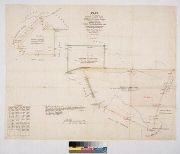
Plat of the Ranchos Azusa and San José and Additions of 1 Square League finally confirmed to Henry Dalton, Ygnacio Palomares & Ricardo Vijar
Manuscripts
Bordered by public lands, Rancho Los Nogales, Rancho Santa Ana del Chino, Rancho La Puente, Rancho of A. Duarte, Azusa Mountains. Addition is to Rancho San José. Colored borders. Hachures indicating hills. Variation 13° 30' East. Containing 27151 327/1000 acres. Surveyed under the Instructions from the U.S. Surveyor General - J.W. Mandeville signature. Inset of Field Notes table with coordinates and distances
mssSolano SR_Map_0008
![Plat of the Rancho Los Cierritos [Cerritos] finally confirmed to Juan Temple](/_next/image?url=https%3A%2F%2Frail.huntington.org%2FIIIF3%2FImage%2F22APN4KPHI01%2Ffull%2F%5E360%2C%2F0%2Fdefault.jpg&w=750&q=75)
Plat of the Rancho Los Cierritos [Cerritos] finally confirmed to Juan Temple
Manuscripts
Bordered by Ranchos Los Alamitos, San Pedro, Los Coyotes, Santa Gertrudes; Pacific Ocean. Inset with extensive table of boundaries. Color highlights; hachures; San Gabriel River; Juan Temple's house indicated, 22194 35/100 acres. Var. 13° 30' E.
mssSolano SR_Map_0037

Rancho San Francisquito: T.1S. R.11W. S.B.M., showing subdivision of public lands
Manuscripts
Bordered by Ranchos Santa Anita, Azusa, La Puente, Potrero de Felipe Lug, Potrero Grande, La Merced. Black & red ink; section numbers & acreage (?) indicated; San Gabriel River & few land features, boundary markers. Title supplied by cataloger.
mssSolano SR_Map_0146