Visual Materials
Map of Delaware Co. New York From actual survey by Jay Gould
You might also be interested in
Image not available
Map of Otsego Co. New York : from actual surveys / by C. & R.C. Gates
Rare Books
Many submaps of small communities. Submaps: Cooperstown and 27 other towns. Vignettes: Cooperstown; Harvesting grapes. Prime meridian: GM. Relief: hachures. Graphic Scale: Miles, rods. Projection: Plane. Printing Process: Lithography. Verso Text: Grafton A Fine Long Cloth.
384727

Topographical Map of Union County, New Jersey, by Ernest L. Meyer and P. Witzel, 1862
Visual Materials
Large wall map, folded, linen backed with varnished surface. Many views in the surround. Vignettes: View of Westfield from the East; View from Prospect Hill; thirty four views of estates, landmarks, manufacturing companies in the surround. Table of statistics of Union County.. "Views sketched from nature by W. T. Crane. Entered according to Act of Congress in the year 1861 by Ernest L. Meyer & P. Witzel in the Clerks Office of the District Court of the Southern District of New York. Orders for maps to be addressed to Ernest L. Meyer City Surveyor, Elisabeth, N. J. or B. Westermann & Co. 440 Broadway, N.Y." Prime meridian: GM, Washington. Relief: hachures. Graphic Scale: Miles, feet. Projection: Plane. Printing Process: Lithography. Other Features: Vignettes.
105:566 M
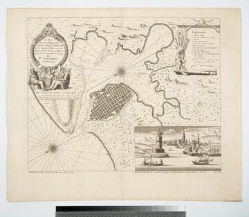
A New and Correct Plan of the City and Harbour of Havana on the Island of Cuba with the Depths of Water, Sands, and Rocks in it from the best and latest surveys by Pr. Chassereau Architect 1739
Visual Materials
Vignette: Harbor of Havana. Cartouche: wreath with figures.. Relief: pictorial. Graphic Scale: Miles, furlongs. Projection: Plane. Printing Process: Copper engraving. Other Features: Vignettes. Verso Text: MS note: 383.
105:383 M
Image not available
Map of the Coast of New England, from Staten Island to the Island of Cape Breton as it was actually surveyed by Capt. Cyprian Southack
Visual Materials
Kashnor notes, "A very good copy of a very rare map. The map of Boston may have been taken from the Bonner Map of 1722, but it is probable that Southack made a new survey. It is the third printed plan of Boston." Kashnor dates as ca. 1740. McCorkle identifies this as a later edition of the 1735 original map. Submaps: Town of Boston in New England; Chart of the Atlantic Ocean showing the situation of Nova Scotia with respect to the British Isles.. Prime meridian: London. Relief: pictorial. Graphic Scale: Miles. Projection: Mercator. Watermark: Fleur-di-lis. Printing Process: Copper engraving. Other Features: Sub-maps. References: McCorkle 735.1. Verso Text: MS notes: 532 East end of Georges Bank from Cape St. Mary to SSW distance 115 miles..
105:532 M
Image not available
A Chart of Part of the South Coast of Newfoundland, including the Islands of Langley, St. Peters and Miquelon, with the Southern Entrance into the Gulph of St. Lawrence, from Actual Surveys taken by order of Commodore Palliser, Governor of Newfoundland, Labradore, &c. by James Cook, Surveyor
Visual Materials
Kashnor notes, "James Cook, afterwards famous as Captain Cook, the explorer, sailed as an able seaman in the Eagle under the command of Capt. Palliser, and his first advancement, as Master of the Mercury was due to the latter's interest in him, and perception of genius." Has submaps and views. Submaps: Port aux Basque; St. Peters Island; Great Jervis Harbour;Harbour Briton; Harbour of St. Lawrence. Views: Cape Ray; Mountain of the Red Hat.. Prime meridian: GM. Relief: no. Graphic Scale: Leagues. Projection: Plane. Printing Process: Copper engraving. Other Features: VignettesSub-maps. Verso Text: Ms nore: 547.
105:547 M
Image not available
A topographical map of Lincoln Co. Maine : from actual surveys / by C.M. Hopkins
Rare Books
Varnished map missing pieces and very fragile. Submaps of Rockland, Wiscasset and other towns. Submaps: Twenty plus towns and villages with directories. Vignettes: Homes & businesses. Prime meridian: GM. Relief: no. Projection: Plane. Printing Process: Lithography.
382836