Visual Materials
A New and Correct Plan of the City and Harbour of Havana on the Island of Cuba with the Depths of Water, Sands, and Rocks in it from the best and latest surveys by Pr. Chassereau Architect 1739

You might also be interested in

Neu und verbesserter Plan der St. u. Hafens Havana auf der Ins. Cuba mit den Wasser Tiefen, Sand haeneken und Klippen nochmahlen über Sohen y. Pr. Chassereau. Anno 1739. ; Neu und verbesserter Plan des Hafen von Carthagena in America, 16°26' Norder Breite, nach dem Entervurf des Pr. Chassereau, Archit. 1740. nach Engelland gebracht und ans Liechtgegeben
Visual Materials
Kashnor notes, "A Dutch issue of the plans published by Bowles in 1739-40, relating to Admiral Vernon's expedition." Printed with map of Cartagena on one sheet, that map dated 1740. See 105:383m for the English version this map is based on. Cartouche: wreath & figures. Vignette: Harbor of Havana. MS note: VL.49 (lower left). Relief: pictorial & hachures. Graphic Scale: Miles. Projection: Plane. Printing Process: Copper engraving. Other Features: CartoucheVignettes. Verso Text: MS note: 377.
105:377a ; 105:377b

Plan of the Colorado Rocks, near the West end of Cuba. ; Plan of the City and Harbour of the Havana
Visual Materials
Two maps on one sheet. Relief: pictorial. Graphic Scale: Leagues. Projection: Plane. Watermark: Shield over LVG VI. Printing Process: Copper engraving. Verso Text: MS note: 386.
105:386
Image not available
Crow Harbour, on the South Side of Chedabucto Bay
Visual Materials
"Surveyed by Thomas Backhouse. 1798.""Engraved by Robt. Lovelace." Houses and hills.. Relief: pictorial & hachures. Graphic Scale: Fathoms. Projection: Plane. Printing Process: Copper engraving. Other Features: Vignettes. Verso Text: MS notes: 600 6.
105:600 M

l'Isle St. Domingue ou Espagnole Decouverte l'an 1492 Par les Espagnols et Dressé Par N. de Fer. Geographe de sa Majesté Catolique A Paris Chez Danet Gendre de l'Auteur sur le Pont N. Dame a la Sphere Royale 1723
Visual Materials
Cartouche: Europeans spearing turtles, black smoking pipe. Vignette: Natives processing sugar cane (?) and gathering fruit. Hunters on islands planes.. Relief: pictorial. Graphic Scale: Leagues. Projection: Cylindrical. Watermark: Chained maltese cross lettering. Printing Process: Copper engraving. Other Features: Cartouche Vignettes. Verso Text: MS note: 784.
093:784 M

The Harbour or River St. John in New Brunswick Surveyed by Thos. Backhouse 1798
Visual Materials
Vignettes: Points, houses & church.. "Stephenson sculp." Relief: no. Graphic Scale: Miles. Projection: Plane. Printing Process: Copper engraving. Other Features: Vignettes. Verso Text: MS note: 527.
105:527 M
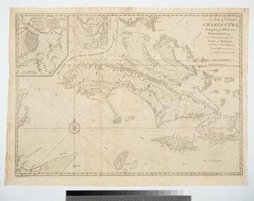
A New & Correct Chart of Cuba, Streights of Bahama, Windward Passage, the Current through the Gulf of Florida, with the Soundings &c. By an Officer in the Navy
Visual Materials
Kashnor dates as ca. 1740. Sub-map: A Plan of the Harbour & Town of Havana. Prime meridian: London. Relief: pictorial. Projection: Mercator. Printing Process: Copper engraving. Other Features: Sub-maps. Verso Text: MS note: 381.
105:381 M