Visual Materials
Neu und verbesserter Plan der St. u. Hafens Havana auf der Ins. Cuba mit den Wasser Tiefen, Sand haeneken und Klippen nochmahlen über Sohen y. Pr. Chassereau. Anno 1739. ; Neu und verbesserter Plan des Hafen von Carthagena in America, 16°26' Norder Breite, nach dem Entervurf des Pr. Chassereau, Archit. 1740. nach Engelland gebracht und ans Liechtgegeben

You might also be interested in
A New and Correct Plan of the City and Harbour of Havana on the Island of Cuba with the Depths of Water, Sands, and Rocks in it from the best and latest surveys by Pr. Chassereau Architect 1739
Visual Materials
Vignette: Harbor of Havana. Cartouche: wreath with figures.. Relief: pictorial. Graphic Scale: Miles, furlongs. Projection: Plane. Printing Process: Copper engraving. Other Features: Vignettes. Verso Text: MS note: 383.
105:383 M
Image not available
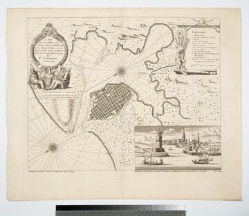
This Plan of the Harbour, Town and Forts of Porto Bello
Visual Materials
Kashnor notes, "A good impression of a very rare map." "(Taken by Edward Vernon Esqr. Vice Admiral of the Blue on the 22d. of November 1739. With Six Men of War only,) Drawn by Lieutent. Philip Durell: Is most Humbly Inscribed to the Rt. Honble. Sir Charles Wager First Lord Commissioiner of the Admiralty." "I do assure the publick that this Plan is exactly copied from the Original (and only) Drawing brought over to me Ja: Rentone. Charing Cross March the 27th 1740." "Price One Shilling. P. Durell delin. November 1739. W. H. Toms Sculpt. 1740." Relief: pictorial. Graphic Scale: Miles. Projection: Plane. Printing Process: Copper engraving. Verso Text: MS note: 902.
105:902 M
Image not available
Charte von den vereinigten Staaten von Nord-America nach murdochischer Projection und den neuesten astronomischen Ortsbestimmungen entworfen und gezeichnet von F. L. Güssefeld, 1805 ; nach den Entdeckungen der Hrn. Lewis, Clarke u. Pike berichtigt im Septbr. 1812 und nach der neuesten Staateneintheilung begräntzt im J.1817
Visual Materials
Kashnor notes, "Probably the earliest map issued in Europe defining the boundaries of the new state of Illinois. It shows the course of the Missouri through the Rockies." In spite of Kashnor's note, this map was actually printed a year before Illinois actually became a state. Lake Michigan is displaced eastward and Michigan narrowed. Prime meridian: Ferro. Relief: hachures. Graphic Scale: Miles. Projection: Pseudocylindrical. Watermark: Crowned fleur-de-lis Lachendorf. Printing Process: Engraving. Verso Text: Ms note: 402.
093:402 M
Image not available
Das norder Theil des Lands Brasilien : darinn die fürnemsten Hafen angedeütet werden, als zu Parayba, Pernambuco, Todos os Santos, und andere
Visual Materials
Kashnor notes, "Consisting of a fine Birds-Eye View of Pernambuco and adjacent Coasts, with a fleet bombarding Pernambuco, and inset map of the Brazilian Coast, from the Island of Taperica to the Mouth of the Rio Grand." Included in the two German editions (1627, 1628) and one Latin (1634) edition of Theodor de Bry's Historiae Americanae, part 13. Kashnor (mistakenly?) dates as [Frankfort, 1631]. Pernambuco is called Recife today. Vignette: Marine battle. Submap: Brazilian coast line. MS note: 880 (on backing). Table of explanation of battle scene in German. Relief: pictorial. Projection: Plane. Printing Process: Copper engraving.
105:880 M