Visual Materials
(1) Port de St. Augustin (2) Port de la Providence (3) La Havane dans l'Isle de Cuba (4) Baye de Sn. Iago dans l'Isle de Cuba (5) Port de Kingston dans la Jamaique (6) Plan du Port Antonio dans l'Isle de la Jamaique, with inset Plan du Fort (7) Isle d'Antigoa l'une des Antilles

You might also be interested in

Port, Baye Cul de Sac Royal dans la Martinique. ; Isle des Barbades une des Isles Antilles. Aux Anglois ; Cartagenas Située sur la Côte de la Nouvelle Espagne dans l'Amerique Septle. ; Port de Porto Belo a la Côte Septle de l'Isthme de Panama. Aux Espanols
Visual Materials
Four maps on one sheet. Relief: no. Graphic Scale: Miles, leagues. Projection: Plane. Watermark: Circular device. Printing Process: Copper engraving. Verso Text: MS note: 510 Q26.
105:510

Plan of the Colorado Rocks, near the West end of Cuba. ; Plan of the City and Harbour of the Havana
Visual Materials
Two maps on one sheet. Relief: pictorial. Graphic Scale: Leagues. Projection: Plane. Watermark: Shield over LVG VI. Printing Process: Copper engraving. Verso Text: MS note: 386.
105:386
Image not available
Plan of New Orleans the Capital of Louisiana; with the Dispositions of its Quarters and Canals as they were traced by Mr. de la Tour in the Year 1720.; Course of the Mississipi River from Bayagoulas to the Sea; The East Mouth of the Mississipi, with the plan of Fort las Balise which defends the Entrance and Channel of that River
Visual Materials
Three maps on one sheet. See also 093:427 for a Dutch version of this map. Three maps on one sheet.. Relief: no. Graphic Scale: Fathoms, miles. Projection: Plane. Watermark: Crowned fleur-di-lis IVG. Printing Process: Copper engraving. Other Features: Sub-maps. Verso Text: MS notes: 436 36.
093:436 S
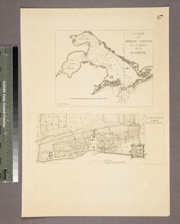
La Baye de Spititu Santo Côte Occidentale De la Floride - S. Augustin Capitale de la floride orientale
Visual Materials
Kashnor notes, "Both chart and plan are copied from Jefferys. The were issued by Le Rouge for the use of French navigators during the Revolution." Kashnor dates as [1778]. See 105:097S for original maps. Two maps on one sheet. MS note: 27. Relief: no. Graphic Scale: Miles, furlongs. Projection: Plane. Watermark: Lettering. Printing Process: Copper engraving. Other Features: Sub-maps. Verso Text: MS note: 96.
105:096 S

Plan of Bahia Honda. ; Plan of Puerto de Cavañas
Visual Materials
Two maps on one sheet. Kashnor dates as ca. 1760. MS notes: 68 69 (upper right). Relief: hachures. Graphic Scale: Miles. Projection: Plane. Watermark: Crowned fleur-di-lis. Printing Process: Copper engraving. Verso Text: MS note: 375.
105:375 M

Plan de la Baye et Rade du Cap Francais dessiné Par M. de Foligne Lieutenant de Fregate du Roi
Visual Materials
Kashnor notes, "A rare map, giving a map of the town and all the old forts to the Cape." Kashnor dates as ca. 1760, submap shows 1780. Sub-map: Carte de St. Domingue 1780. Relief: hachures. Graphic Scale: Miles. Projection: Plane. Watermark: Chained Maltese cross lettering. Printing Process: Copper engraving. Other Features: Sub-maps. Verso Text: MS note: 422.
105:422 M